A NASA satellite double-take at Hurricane Lowell

Lowell is now a large hurricane in the Eastern Pacific and NASA's Aqua and Terra satellites double-teamed it to provide infrared and radar data to scientists. Lowell strengthened into a hurricane during the morning hours of August 21.
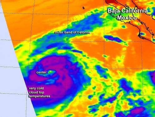
When NASA's Aqua satellite passed over Lowell on August 20 at 21:05 UTC (4:05 p.m. EDT), the Atmospheric Infrared Sounder got an infrared look at Lowell's cloud top temperatures when it was still a tropical storm. AIRS showed a very thick band of thunderstorms surrounding the center of circulation and what appeared to be a very small cloud-free center of circulation, like the formation of an eye. Cloud top temperatures exceeded -63F/-52C, the threshold for high, cold thunderstorms with the potential for dropping heavy rainfall.
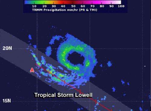
The TRMM or Tropical Rainfall Measuring Mission satellite passed over Lowell on August 21 at 01:14 UTC and captured rainfall rates and cloud height data. TRMM showed that moderate rainfall circled the center of the storm, with rain rates to about 30 mm per hour. A large band of thunderstorms extending southwest of the center also contained moderate rainfall. TRMM found that cloud tops in that band of thunderstorms were about 6.2 miles (10 km) high. TRMM is managed by NASA and the Japan Aerospace Exploration Agency.
Lowell became the seventh hurricane of the Eastern Pacific Ocean season today, August 21 at 11 a.m. EDT (1500 UTC). Maximum sustained winds had increased to 75 mph (120 kph) making Lowell a Category One hurricane on the Saffir-Simpson Wind Scale. Little change in intensity is forecast by the National Hurricane Center (NHC) today, and NHC forecasters expect a slow weakening trend later today through August 22.

It was centered near latitude 20.0 north and longitude 122.1 west, about 810 miles (1,300 km) west-southwest of the southern tip of Baja California, Mexico. It is moving to the northwest near 3 mph (4 kph) and is expected to move faster in that direction over the next two days.
There are no coastal watches or warning in effect.
Provided by NASA's Goddard Space Flight Center


