Satellite data measures Nile water for region security

War and other social and economic problems could be prevented in north-eastern Africa now that the total water storage of the Nile Basin can be measured, according to a WA professor.
Curtin University Department of Spatial Sciences' Joseph Awange says being able to measure the total water storage of the Nile Basin is significant for the countries that drain water from it because they may be in jeopardy of dishonouring the Nile Waters Agreement.
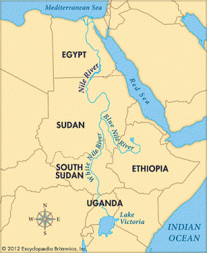
"If you look at it from water decision issues, the Nile is really a significant water body in the region and Egypt has threatened to go to war several times in case the upper countries overuse the water," Associate Professor Awange says.
"When I say upper countries I mean countries where the Nile begins like Kenya, Uganda, and Ethiopia."
A/Prof Awange says countries draining water from the Nile can now make better informed decisions about how much water to take and what to use it for.
"If war was to erupt in the region, certainly it would be because of the Nile water resources," he says.
A/Prof Awange and other researchers collected satellite data between the years 2002 and 2011.

The group used data from the Gravity Recovery And Climate Experiment (GRACE) mission, which detects spatio-temporal variations of the earth's gravity field.
However, use of this satellite data to determine the total water storage (TWS) of the Nile is difficult because stronger signals over the Lake Victoria Basin and the Red Sea obscure those from smaller sub-basins.
To overcome this problem, the study used an advanced mathematical technique called Independent Component Analysis to extract independent TWS patterns in sub-basins from GRACE and the Global Land Data Assimilation System.
A/Prof Awange says it is physically impossible to measure TWS of the entire basin with conventional measurement techniques.
He says the study also has economic implications because many of the fish eaten in Europe—like Nile Perch—come from the Lake Victoria region of the Nile.
He hopes more studies of similar nature will be carried out in the region, allowing for further understanding about the effects of climate change on the Nile Basin.
"The longer period of data we have, the more it will enable us to look at climatological analysis in the region," he says.
A/Prof Awange says an improved version of GRACE will be released in 2017 and will bring more precise data measures.
Provided by Science Network WA


