NASA's TRMM satellite analyzes Mexico's soaking tropical rains

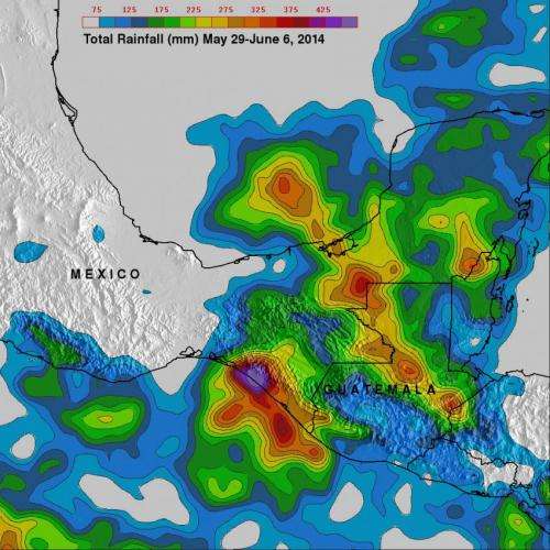
The movement of tropical storm Boris into southern Mexico and a nearly stationary low pressure system in the southern Gulf of Mexico caused heavy rainfall in that area. NASA and the Japan Aerospace Exploration Agency's Tropical Rainfall Measuring Mission satellite known as TRMM acts like a "rain gauge in space" and calculated that one area received almost 2 feet of rainfall.
The TRMM-based, near-real time Multi-satellite Precipitation Analysis (TMPA) at the NASA Goddard Space Flight Center in Greenbelt, Maryland monitors rainfall over the global tropics using data from the TRMM satellite. TMPA rainfall totals were calculated for the period May 29 to June 6, 2014 that covered the time that Tropical Storm Boris made landfall in southwestern Mexico and System 90L soaked eastern Mexico.
TRMM data showed the highest rainfall totals of over 535 mm where tropical storm Boris came ashore in southern Mexico. System 90L, located in the Bay Of Campeche for most of that time brought more heavy rain in southeastern Mexico before it dissipated on June 7.
On June 7, there was good and bad news about System 90L. The good news was that it moved further inland and was dissipating so it no longer had a chance to develop into a tropical cyclone. The bad news was that it moved further inland and continued to produce gusty winds and heavy rains along with life-threatening flash flooding over eastern and southeastern Mexico.
At NASA's Goddard Space Flight Center in Greenbelt, Maryland, the NASA/NOAA GOES Project created an animation of satellite imagery from NOAA's GOES-East satellite imagery. The movie shows the movement of System 90L over land and dissipating between June 6 and June 7 at 2000 UTC (4 p.m. EDT).
The Mexican Weather Service reported the city of Veracruz recorded 7.1 inches (180 mm) of rain! Huixtepec in Oaxaca reported 2.9 inches (73.4 mm) of rain.
On June 7, the National Hurricane Center noted that the low was centered near 18.0 north and 96.5 west. By June 9, System 90L had dissipated.
Provided by NASA's Goddard Space Flight Center


