Engineers taking Earth-based measurements to calibrate NASA's newest weather satellite
(Phys.org) —After Atlanta was paralyzed by a rare snowstorm, many fingers were pointed assigning blame for the resulting traffic catastrophe, including at least one aimed at imprecise weather predictions.
"The governor of Georgia said that they thought the heavier snowfall was going to be south of the city," said Ana Barros, professor of civil and environmental engineering at Duke University. "But there's a lot of uncertainty in those predictions because we don't really understand the fine details of complex storm systems. We don't know how to model these processes at high spatial resolutions."
This summer, Barros and her colleagues will conduct the first field mission with a new satellite system intended to fill in those knowledge gaps. On Feb. 27, NASA and JAXA—Japan's national space agency—launched the core satellite for their new Global Precipitation Measurement (GPM) mission from Japan's Tanegashima Space Center.
GPM is an international satellite mission designed to provide more detailed measurements of rain and snow over a wider range of the globe than previously possible. Not only will the satellite have more precise instrumentation than its predecessors; its orbit will allow researchers to study rainfall at higher latitudes at higher spatial and temporal resolutions. The data it collects will help unify measurements made by partner satellites and add to science's understanding of how weather works.
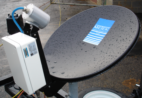
Before meteorologists can start plugging the new data in to their weather models, however, researchers have to make sure they can accurately interpret the GPM measurements. The upcoming field mission, based in the mountains of western North Carolina and led by Duke engineers, will help achieve this by comparing satellite readings with those taken simultaneously from multiple aircraft and ground sensors. Besides calibrating the new satellite, the campaign will help improve how precipitation processes are represented in forecast calculations. It will also provide data and inform models used to address critical water management issues in mountainous regions.
"The campaign that we are running will obtain very high-resolution data of precipitation and the microphysics of storm systems in mountainous regions," said Barros. "The end goal is to improve weather predictions and climate models."
Between May 1 and June 15, measurements will be taken on the ground and by two aircraft flying at different altitudes to compare with the newly launched GPM satellite. The data collected will help calibrate the new satellite's sensors for the rest of its long-term mission to study complex weather phenomena.
The campaign will also be the first of its kind in mountainous regions that, according to Barros, are home to complex rain patterns that are one of the biggest challenges in remote sensing. The Great Smoky Mountains get their name from microdroplet rain patterns that are difficult for satellites to probe with their sensors.
After the initial field campaign ends on June 15, the two participating aircraft will move on to other missions, but Barros and her team will continue taking data from the new satellite and the extensive ground sensor network they have built until the effective end of the hurricane season.
"When we first started in 2007, there were only two rain gauges reliable for these kinds of studies above 3,200 feet in the whole eastern United States," said Barros. "Now, for this experiment, we have more than 100. It's taken a long time to get here, but we've had a lot of help along the way.
"We've been working with a handful of non-governmental organizations along with water authorities, planning commissions," Barros said, "and literally dozens of independent entities, including the Haywood Community College, the Haywood Electric Membership Cooperation, Wilson College, UNC-Asheville, Maggie Valley Water District, Pisgah Astronomical Research Institute, ABTech, and even local landowners and landmarks, like Joey's Pancake House, who have been very supportive of our field work."
Provided by Duke University


