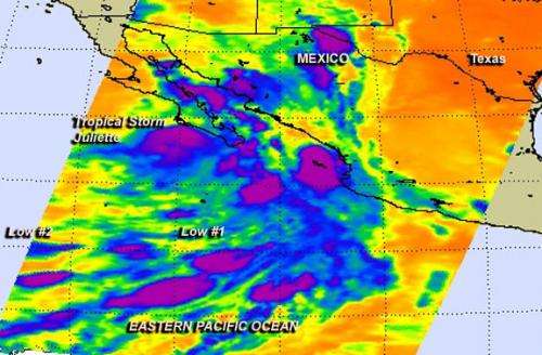
NASA sees Tropical Storm Juliette waning near Mexico's Baja California

August 29, 2013 brought a lot of tropical activity back to the Eastern Pacific Ocean. Late on Aug. 28, Tropical Storm Juliette formed just west of the coast of Baja California, Mexico, and two other low pressure areas developed south and southeast of the storm. NASA's Aqua satellite captured Juliette and the low pressure areas in infrared imagery.
NASA's Aqua satellite passed over the Eastern Pacific Ocean on Aug. 29 at 08:53 UTC/4:53 a.m. EDT, and the Atmospheric Infrared Sounder or AIRS instrument captured an infrared look at the region. AIRS data showed Tropical Storm Juliette near the western coast of the Baja California peninsula. Satellite data shows that only a small area of thunderstorms remained around Juliette's center. Some of the thunderstorms did have very cold cloud top temperatures near -63F/-53C, which is indicative of heavy rainfall.
During the morning of Aug. 29, a Tropical Storm Warning was in force for the west coast of the Baja California peninsula, from Puerto San Andresito to Punta Eugenia. Juliette is expected to produce total rainfall amounts of 1 to 3 inches over southern portions of the Baja California Peninsula.
Tropical Storm Juliette formed on Aug. 28 at 5 p.m. EDT from System 95E that had been hugging the western Mexico coast for several days. Juliette was born near 21.5 north and 108.6 west, just 130 miles/205 km southeast of Cabo San Lucas, Mexico and had maximum sustained winds near 45 mph/75 kph.
By 11 a.m. EDT/1500 UTC on Aug. 29, Tropical Storm Juliette had maximum sustained winds near 40 mph/65 kph. The National Hurricane Center expects Juliette to weaken later in the day. Juliette was centered near latitude 25.7 north and longitude 113.1 west, just about 80 miles/130 km northwest of Cabo San Lazaro, Mexico. Juliette is moving toward the northwest near 22 mph/35 kph but is expected to slow down later today.
The National Hurricane Center expects that Juliette will turn to the west-northwest and slow down on Aug. 30. Juliette's center will keep moving along or near the west coast of the Baja California Peninsula through the evening hours of Aug. 29, and weakening because it continues to interact with the coast, and is moving into cooler waters. Juliette is forecast to become a remnant low tonight or Friday.
There are two other low pressure areas in the Eastern Pacific, but they are expected to be slow to develop.
The first low pressure area is located about 800 mile south-southwest of the southern tip of Baja California. It's a broad area of low pressure that is generating a large area of clouds and some showers. AIRS data showed that there were some thunderstorms in this low capable of dropping heavy rainfall. Some storms had very cold cloud top temperatures near -63F/-53C which tells scientists that the thunderstorms were extending high into the troposphere. That low is moving to the northeast or north-northeast at 10 mph. It has a 10 percent chance for development for the next day or two, before it reaches cooler waters.
The second low pressure area lies to the west of the first low. That low is located 1,500 miles west-southwest of the southern tip of the Baja California peninsula, and satellite data showed that shower activity decreased from the previous day. This low is moving northward and has a 20 percent chance of development in the next two days, according to the National Hurricane Center.
Provided by NASA's Goddard Space Flight Center


