Fernand's remnants still drenching eastern Mexico

Tropical moisture continued to stream over eastern Mexico on Aug. 27, from the remnants of former Tropical Storm Fernand. NASA's TRMM satellite captured the moisture-laden Tropical Storm Fernand after it made landfall and was dropping rainfall at a rate of 2 inches/50 mm per hour.
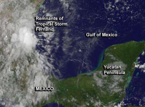
On Aug. 27 at 10:32 EDT, radar data from Mexico showed rainfall streaming in from near the city of Tampico on the Gulf of Mexico, to the west and northwest. Areas including Ebano and Panuco were experiencing heavy rainfall at the time. The center of Fernand's remnants were near 20.6 north latitude and 98.5 west longitude, which is between the states of Hidalgo and Veracruz. Fernand's remnants are keeping the region cloud-covered, as seen on NOAA's GOES-East satellite imagery. The GOES imagery, created by NASA's GOES Project at NASA Goddard Space Flight Center
The National Meteorological Service or NMS of Mexico expects Fernand's remnants to generate intense and heavy rain to the northeastern states, east and central Mexico. A warning remains in effect for heavy rainfall. The NMS of Mexico noted that heavy rainfall is possible on Aug. 27 in Veracruz, Puebla, Hidalgo, San Luis Potosi and Tamaulipas. Heavy rainfall is also possible in Distrito Federal, Tlaxcala and Queretaro.
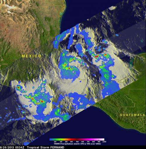
On Monday August 26 at 0534 UTC (1:34 a.m. EDT), Tropical Storm Fernand was already drenching the state of Veracruz along Mexico's eastern coast on the Gulf of Mexico when NASA's TRMM satellite flew overhead. TRMM, the Tropical Rainfall Measuring Mission Satellite captured data about the rainfall rates occurring in Fernand at the time.

That data was visualized at NASA's Goddard Space Flight Center in Greenbelt, Md. A rainfall analysis from TRMM's Microwave Imager (TMI) and Precipitation Radar (PR) instruments was overlaid on an enhanced infrared image from TRMM's Visible and InfraRed Scanner (VIRS). The TRMM PR found rain falling at a rate of over 118mm/~4.6 inches per hour in rain bands north of Fernand's center of circulation. Those same TRMM PR data clearly showed the location of Fernand's nearly rain free center of circulation.
TRMM's Precipitation Radar (PR) data were used at NASA to create a 3-D image of the storm's structure. TRMM also captured imagery of nearby System 95E in the eastern Pacific. In that storm, the tallest thunderstorm tops were found to reach heights of above 18.5 km/~10.9 miles. Those powerful storms were located off Mexico's Pacific coast southeast of Acapulco.
Heavy rainfall from Fernand may still produce some life threatening flash floods and mudslides today.
Provided by NASA's Goddard Space Flight Center


