Underground permeation of seawater in tsunami disaster areas caused by 2011 earthquake
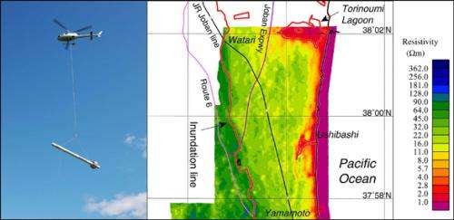
Researchers from the National Institute of Advanced Industrial Science and Technology (AIST) conducted an airborne electromagnetic survey by helicopter in Watari-cho and Yamamoto-cho of Watari-gun in Miyagi Prefecture and Shinchi-machi of Soma-gun and Soma city in Fukushima Prefecture in June 2012 in order to investigate the underground permeation of seawater in tsunami disaster regions caused by the 2011 off the Pacific coast of Tohoku Earthquake.
This survey revealed that low apparent resistivity layers with resistivity below 20 Ωm, where electricity can easily pass through, are widely distributed in the shallow underground part (depth of approximately 0 to 5 m) over several kilometers from the coastline toward inland areas and that the boundary of the distribution zone almost matches the edge of the tsunami flooding zone. In the deep underground part of the distribution zone (depth of 10 m or more), low-resistivity layers resulting from the penetration of water from the coast were frequently observed. However, layers of relatively high resistivity were also observed. There is a possibility that fresh groundwater exists near these high-resistivity layers, and this is expected to contribute to the selection of candidate sites for drilling new groundwater wells.
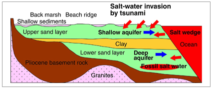
In the surveyed tsunami disaster areas, the lower sand layer, clay layer, and upper sand layer are stacked in sequence above the Pliocene bedrock (Fig. 2). Unconfined groundwater exists in the upper sand layer, and confined groundwater exists in the lower sand layer. This region is close to the coastline, so even at regular times it is affected by seawater. Also, fossil salt water created by the penetration of seawater and changes in the sea level is known to exist deep underground below coastal areas. In addition to these, the salinization of unconfined shallow groundwater due to flooding from the tsunami has become an issue. Therefore, understanding and continuously monitoring groundwater pollution is necessary in order to ensure fresh groundwater that can be used without concern. In Watari-cho and Yamamoto-cho of Watari-gun in Miyagi Prefecture, there is extensive rice cultivation as well as the greenhouse cultivation of strawberries. Therefore, ensuring fresh groundwater for strawberry sprinklers and greenhouse heating is an urgent matter.
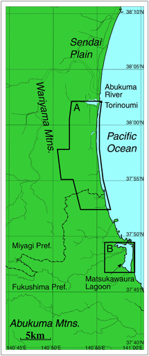
By the FY2011 supplementary budget, "Evaluation of complex geological risks associated with large earthquakes and tsunami disasters", AIST is comprehensively studying the complex risks in the regions ranging from the land to shallow seawaters associated with the tsunami, inland earthquakes, liquefaction, and soil and groundwater pollution caused by the 2011 off the Pacific coast of Tohoku Earthquake. This study is being conducted to assist with recovery plans in the disaster areas. As a part of the study, the researchers conducted an airborne electromagnetic survey by helicopter to investigate the underground penetration of seawater and the distribution of fresh groundwater beneath the penetrated seawater in tsunami disaster areas (Fig. 2, Watari-cho and Yamamoto-cho of Watari-gun in Miyagi Prefecture and Shinchi-machi of Soma-gun and Soma city in Fukushima Prefecture).
This survey was conducted along east-west survey lines spaced 100-m apart. The transmitter of electromagnetic survey equipment in a bird hung from a helicopter was used to produce magnetic fields of 5 frequencies (340 Hz, 1.5 kHz, 6.9 kHz, 31 kHz, and 140 kHz), and secondary magnetic fields produced in response to resistivity, the index of how difficult it is for electricity to pass through the ground, were received by the receiver of the electromagnetic survey equipment in the same bird. Then, apparent resistivity data were obtained for each frequency from the observed data.
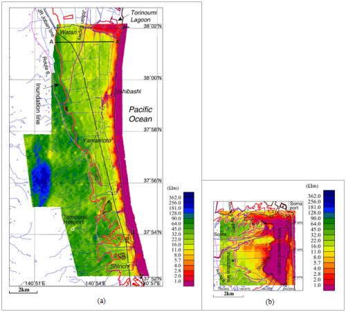
The apparent resistivity distribution at the highest frequency (140 kHz) corresponded to the distribution at the shallow underground part (depth of approximately 0 to 5 m), and a very low-resistivity value of 4.0 Ωm or below was observed near the coastline of the southern Sendai plain (Fig. 3 (a)). This low resistivity was thought to be due to the penetration of seawater from the coast. Meanwhile, in regions several kilometers or less from the coastline toward inland areas, low-resistivity layers of 20 Ωm or below were widely distributed, and the boundary of the distribution zone matched the edge of the tsunami flooding zone (inundation line) well. This was believed to be due to a decrease in the resistivity of the soil and shallow strata (normally several tens of Ωm or more) caused by seawater (resistivity: 0.25 Ωm) flooding from the tsunami. The survey results in the Matsukawaura region (Fig. 3 (b)) were similar. However, the area inland from the lake shoreline showed extremely low resistivity of 4.0 Ωm or less. The low-resistivity area was wider than the southern Sendai plain. This is thought to be due to the fact that seawater from the tsunami remained on the ground surface in this region longer than it did in the southern Sendai plain.
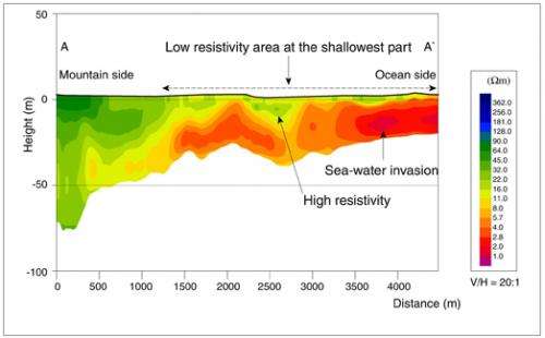
At the deep underground part (deeper than 10 to 20 m) in the southern Sendai plain, a layer of low resistivity from 2.0 to 11.0 Ωm extends from near the shoreline to inland areas, but at agricultural drainage canals, etc., low-resistivity regions were found even deeper underground. This is thought to be due to the permeation of seawater from the ocean to the ground through agricultural drainage canals (Fig. 4).
Layers of relatively high resistivity were found enclosed by this low-resistivity layer. The characteristic of this type of resistivity distribution is similar to the freshwater lens form. Therefore, there is a possibility that fresh groundwater exists in the distribution zone of the high-resistivity layers, and the layers can be candidate sites for new groundwater supply sources.
In order to further analyze the apparent resistivity distribution by airborne electromagnetic survey and to reveal the structure of deeper resistivity layers, the researchers also implemented electromagnetic survey and high-density electrical prospecting, etc. on the ground in the areas investigated in the present survey. In the future, they will conduct a comparative study of these data and use drilling to confirm whether fresh groundwater that can be used as a shallow water source actually exists, etc.
Provided by Advanced Industrial Science and Technology


