Sandy's surge affected more than 1.4 million in 11 states
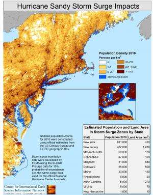
This map depicts the coastal areas likely to have been inundated by the storm surge resulting from Hurricane Sandy in relationship to residential population. It is based on a model used by the U.S. Federal Emergency Management Agency (FEMA) to predict the effects of hurricanes and other coastal storms on low-lying coastal regions.
Storm surge is an abnormal rise of water generated by a storm, over and above astronomical tides. Storm surge is sensitive to many factors, including the track, speed and intensity of the storm and coastal features such as bays and estuaries. Key factors in surge height are the length and depth of the continental shelf – which in the New York area is relatively long and shallow – allowing waves to build up to considerable heights as they reach land. The extent and depth of inundation are very localized and depend not only on storm surge height but also on other factors such as the timing relative to high tide, wind direction and speed, the topography inland from the coast, and the presence of wetlands and protective works.
The table shows the number of people who resided in 2010 within the estimated flood zone by state. New York has the highest total, with more than 800,000 residents living in areas likely to have been affected by the storm surge. New Jersey had about half as many people affected as did New York, spread over a larger area. Since these estimates are based on residency, these totals do not include owners of seasonal or second homes located in the flood zone.
The inset in the lower right zooms in on Staten Island, other parts of New York City and northern New Jersey, where population density is highest. The jagged edges in the inset reflect the spatial resolution of the population data, which is based on a latitude-longitude grid of one kilometer.
Hurricane Sandy formed in the Tropical Atlantic on Oct. 22 and moved up the coast over several days. On Oct. 29, it took a sharp left turn as predicted by forecasters, and made landfall that same day. Although its wind speeds had dropped below hurricane levels at this point, its high winds affected a huge area of the Atlantic Coast and it led to record storm surges in many areas.
Provided by Columbia University


