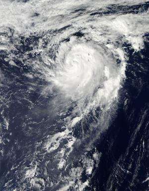
NASA: How do you solve a problem like (Tropical Storm) Maria?

The song "How do you solve a problem like Maria?" from the famous film "The Sound of Music" comes to mind when looking at NASA satellite imagery of Tropical Storm Maria churning in the western North Pacific Ocean. The answer lies in increased wind shear and cool ocean temperatures – two factors that can weaken the storm, but won't be present over the next day or two.
NASA's Aqua satellite passed over Tropical Storm Maria on Oct. 16 at 0355 UTC, 12:55 p.m. local time Tokyo/Japan (Oct. 15 at 11:55 p.m. EDT) and the Moderate Resolution Imaging Spectroradiometer (MODIS) instrument captured a visible image of the storm when it was approaching Iwo To, Japan. The image shows that Maria had a strong circulation with bands of thunderstorms wrapping around the center from the south and east and into the center from the north.
On Oct. 16 at 0900 UTC (5 a.m. EDT), Maria had maximum sustained winds near 55 knots (63.2 mph/102 kph). It had passed Iwo To and was located about 135 nautical miles (155 miles/250 km) north of the island, moving north-northeast at 15 knots (17.2 mph/27.7 kph).
Although increased wind shear and cooler waters would weaken Maria, neither of those factors will be present over the next couple of days as the storm moves to the north-northeast over open waters. In fact, on Oct. 16, a satellite image from NASA's Tropical Rainfall Measuring Mission (TRMM) satellite showed that the center is consolidating and that bands of thunderstorms are more tightly curved around the center. The TRMM data also revealed an eye feature.
Maria is moving around a ridge (elongated area) of high pressure. High pressure circulates in a clockwise direction, and Maria is on the western side of the high, so it will be curving to the northeast as it continues moving around. The Joint Typhoon Warning Center expects that Maria may become extra-tropical in three days.
Provided by NASA's Goddard Space Flight Center


