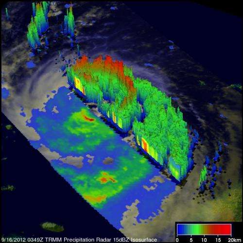
TRMM satellite measures drenching rains from Typhoon Sanba in Japan, South Korea

Heavy rainfall from Typhoon Sanba caused flooding, landslides and at least one death when it hit South Korea on Monday September 17, 2012. NASA's TRMM satellite captured rainfall and thunderstorm cloud height data as Sanba drenched southwestern Japan earlier, and its eye passed to the west of the Japanese island of Kyushu.
The Tropical Rainfall Measuring Mission (TRMM) satellite provided good coverage of Sanba as it passed over Typhoon Sanba on Sept. 16, 2012 at 0349 UTC, after Sanba had passed over Okinawa, Japan. Sanba was moving northward over the East China Sea toward South Korea and its circulation was affecting western Japan.
Later, the TRMM satellite again passed over Sanba on Sept. 16, 2012 at 2339 UTC (7:39 p.m. EDT). Data from TRMM's Microwave Imager (TMI) and Precipitation Radar (PR) instruments showed that Sanba was concentrating rain at a rate of over 90 mm (~3.5 inches) per hour in an area near South Korea's southern coast. TRMM saw that rain bands from Sanba were still producing scattered heavy showers as far away as the Japanese island of Shikoku.
TRMM Precipitation Radar (PR) data collected with the September 16, 2012 0349 UTC pass were used to create a 3-D cut-away view of the storm, looking from the northwest. At that time, the typhoon had weakened slightly but was still a strong category two typhoon with wind speeds of about 95 knots (~109 mph). The 3-D image showed powerful thunderstorms around Sanba's eye wall were about 12km (~7.5 miles) high. However, the tallest thunderstorm towers, reaching to 14km (~8.7 miles), were found by TRMM PR in an intense rain band shown circulating south of Sanba center.
On Sept. 17, Typhoon Sanba made landfall in the south Gyeongsang Province, located on the southern coast of South Korea.
Provided by NASA's Goddard Space Flight Center


