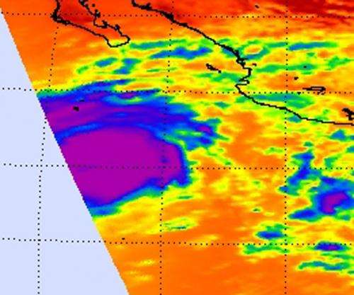
NASA's satellite saw 'power-trigger' around Hurricane Miriam's center

ASA's Aqua satellite revealed a large area of powerful thunderstorms around the center of Tropical Storm Miriam on Sept. 23 as it tracked through the Eastern Pacific Ocean. That power was the trigger that helped Miriam rapidly intensify into a major hurricane on Sept. 24.
NASA's Aqua satellite passed over the eastern Pacific Ocean on Sept. 23 and the Atmospheric Infrared Sounder (AIRS) instrument captured an infrared image of Tropical Storm Miriam's cloud top temperatures. Tropical Storm Miriam is born that day, about 640 miles (1,025 km) south-southeast of the southern tip of Baja California. Cloud top temperatures are an indication of uplift in a storm. Uplift is the push of air upward that allows formation of towering clouds and thunderstorms that make up a tropical cyclone. The infrared data indicated a large area of strongest thunderstorms and heaviest rainfall surrounding the center of circulation. Those cloud top temperatures exceeded -63 Fahrenheit (-52 Celsius).
On Friday, Sept. 24 at 11 a.m. EDT, Tropical Storm Miriam became an eastern Pacific hurricane with maximum sustained winds near 120 mph (195 kmh). Miriam was located about 410 miles (655 km) south-southwest of the southern tip of Baja California, Mexico, near latitude 17.7 North and longitude 112.9 West. Miriam is moving northwest near 12 mph (19 kmh) and a gradual turn to the west and southwest is expected later.
Visible imagery from NOAA's GOES-15 satellite suggests the formation of a small eye, while NASA's Tropical Rainfall Measuring Mission (TRMM) satellite data suggest that an outer eyewall is forming. The National Hurricane Center noted that barring an eyewall replacement, Miriam could strengthen even more in the next day.
Provided by NASA's Goddard Space Flight Center


