Tropical Storm Ernesto was an unwelcome visitor in St. Lucia

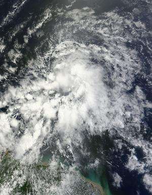
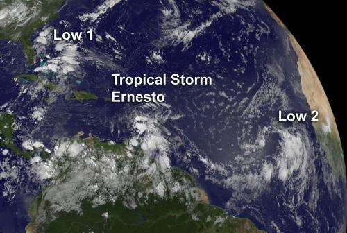
The fifth Atlantic Ocean tropical depression strengthened into Tropical Storm Ernesto on Thursday, August 2 at 5 p.m. EDT and tracked over St. Lucia early on August 3. NASA's Terra satellite captured an image of Ernesto from space as it approached the island.
On August 2, 2012 at 1420 UTC (10:20 a.m. EDT) the Moderate Resolution Imaging Spectroradiometer (MODIS)instrument onboard NASA's Terra satellite captured a stunning visible image of Tropical Storm Ernesto as it was approaching the Lesser Antilles. The image showed the highest, strongest thunderstorms from the northern to the eastern and southern quadrants of the storm. Some thunderstorms were so high in the troposphere that they were casting shadows on the lower surrounding thunderstorm cloud tops.
On August 3 at 8 a.m. EDT, Ernesto's maximum sustained winds were near 45 mph (75 kmh). The National Hurricane Center (NHC) reported a wind gust in Saint Lucia during the morning of August 3. During the 7 a.m. EDT hour, Ernesto's center moved over or near Saint Lucia, according to the NHC. By 8 a.m. EDT, Ernesto had moved 40 miles (65 km) away from Saint Lucia, to the west-southwest. Ernesto was near 13.5 North and 61.5 West, and speeding to the west at 24 mph (39 kmh).

As a result of Ernesto's speeding, the government of Trinidad has discontinued the tropical storm watch for Grenada and its dependencies. However, a Tropical Storm Warning is in effect for Dominica, St. Lucia, Martinique and Guadeloupe.
The NHC expects Ernesto to continue speeding westward through the eastern Caribbean Sea near the same rate of speed over the next day or two.
Provided by NASA's Goddard Space Flight Center


