NASA sees Tropical Storm Bolaven making landfall in North Korea

Tropical Storm Bolaven weakened as it moved north through the cooler waters of the Yellow Sea in the last day, which is good news for North Korea and southeastern China where it is making landfall today, Aug. 28.
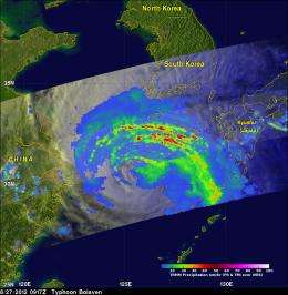
On Aug. 27, NASA's Tropical Rainfall Measuring Mission or TRMM satellite monitored the rainfall rates within Tropical Storm Bolaven. At the time TRMM passed over, Bolaven was still a typhoon. TRMM captured rainfall data at 0917 UTC (about 5:17 p.m. Korea local time/5:17 a.m. EDT) and at 12:33 UTC (8:33 p.m. Korea local time/8:33 a.m. EDT). Bolaven has been generating heavy rainfall and that has been falling over both South and North Korea. Data from TRMM's Microwave Imager (TMI) and Precipitation Radar (PR) instruments showed that numerous rain bands north of Bolaven's center were dropping precipitation at a rate greater than 75 mm/hr (~2.95 inches). That heavy rainfall is cause for concern of flooding as Bolaven makes landfall and moves inland over North Korea and southeastern China.
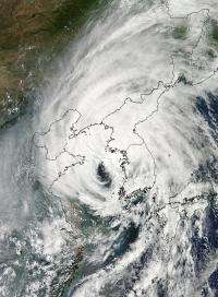
At 12:55 a.m. EDT (4:55 UTC/12:55 p.m. Korea local time) on Aug. 28, the Moderate Resolution Imaging Spectroradiometer (MODIS) instrument on NASA's Aqua satellite captured a high-resolution visible image of Tropical Storm Bolaven centered in the Yellow Sea. Its center of circulation was cloud-free and appeared very large on satellite imagery. Bolaven's cloud cover was extensive and blanketed North and South Korea, southeastern China and southern Japan.
Both the TRMM and the MODIS imagery were created at NASA's Goddard Space Flight Center in Greenbelt, Md. The data from both satellites is shared with the forecasters at the Joint Typhoon Warning Center who use it to make their forecasts.

On Aug. 28 at 0900 UTC (5 a.m. EDT/5 p.m. local time, North Korea), Tropical Storm Bolaven had maximum sustained winds near 55 knots (63.2 mph/102 kmh). It was located about 115 nautical miles (132.3 miles/213 km) west of Seoul, South Korea near 38.1 North latitude and 124.9 East longitude. Bolaven was moving to the north-northeastward at 23 knots (26.4 mph/42.6 kmh) and generating very rough waters in the Yellow Sea, with wave heights to 34 feet (10.3 meters).
Forecasters at the Joint Typhoon Warning Center (JTWC) noted that multi-spectral satellite imagery is showing today, Aug. 28, that the low-level circulation center is expanding and deteriorating as stratocumulus clouds surround the system. Wind shear from the south-southeast has been pushing the bulk of clouds and showers to the north and northeast of the center of circulation, over North and South Korea.
The JTWC forecast calls for Bolaven to continue moving to the north-northeast into Northern Korea later on Aug. 28 and become extra-tropical over land in the next day.
Provided by NASA's Goddard Space Flight Center


