NASA satellite sees massive Tropical Storm Meari headed for Taiwan

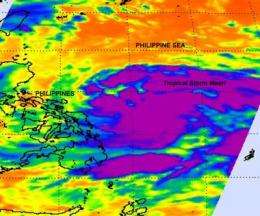
The AIRS instrument on NASA's Aqua satellite captured an infrared image of the western North Pacific's seventh tropical depression become massive Tropical Storm Meari overnight. Meari is so large that it takes up almost the entire Philippine Sea and it's on track toward southeastern Taiwan.
Tropical Storm Meari's large area of cold thunderstorm cloud tops were captured on an infrared image from NASA's Atmospheric Infrared Sounder (AIRS) instrument on June 21 at 17:11 UTC (1:11 p.m. EDT). The strongest thunderstorms covered an area of hundreds of miles around what oddly appears to be two possible low-level circulation centers within the storm. There is one more dominant low-level circulation center where bands of thunderstorms are wrapping around it from the north. The secondary low-level center appears to be to the southeast where more bands of thunderstorms are wrapping around it from the southwest.
On June 22, Tropical Storm Meari had maximum sustained winds near 40 knots (46 mph/74 kmh)with higher gusts. It is about 315 nautical miles east-northeast of Manila, Philippines near 16.0 North and 125.9 East. It was moving northwestward near 15 knots (17 mph/28 kmh).
Meari is forecast to keep moving to the northwest for the next two days. It is expected to strengthen to typhoon status over that time, and before it reaches Taiwan. Forecasters at the Joint Typhoon Warning Center then expect Meari to cross into the Taiwan Strait and make cross over the eastern tip of China.
Provided by NASA's Goddard Space Flight Center


