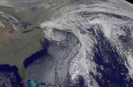
GOES-13 satellite sees cold front stalking remnant low of Tomas

The GOES-13 satellite is watching a flurry of activity in the Atlantic Ocean today as a cold front approaches the remnants of Hurricane Tomas and threatens to swallow it in the next couple of days.
Tomas is now a remnant low pressure area is located in the Atlantic near 26 North and 68 West hundreds of miles south-southwest of Bermuda and has a minimum central pressure of 994 millibars today, Nov. 8. A cold front off the U.S. East Coast however, is stalking Tomas' remnants and moving east threatening to swallow the former hurricane.
The Geostationary Operational Environmental Satellite known as GOES-13 captures visible images of the eastern half of the U.S. and Atlantic Ocean basin during daylight hours and infrared images during night-time hours. Two GOES satellites cover the U.S., one the western half of the country, and the other, GOES-13, the eastern half of the country. GOES satellites are operated by NOAA, and the NASA GOES Project at NASA's Goddard Space Flight Center in Greenbelt, Md. creates images and animations using the satellite data.
GOES-13 captured an image of the cold front stalking Tomas' remnants in the Atlantic Ocean on Nov. 8 at 1345 UTC (8:45 a.m. EST). The cold front appears on the satellite imagery as a line of clouds east of the U.S. East coast that looks like a question mark. Tomas' remnants appear as a tight swirl of clouds at the bottom of that line of clouds near Bermuda.
By 6 p.m. Eastern Standard Time on Nov. 7, Tomas had lost its tropical characteristics and its warm core. Tomas had more resembled a frontal system with cold air stratocumulus clouds wrapping into its center. At that time, Tomas was about 500 miles south-southwest of Bermuda near 26.1 North and 69.1 West. It still had maximum sustained winds of 60 mph, and more resembled a nor'easter meteorologically speaking. It was moving north-northeast near 3 mph and had a minimum central pressure of 997 millibars at that time. When Tomas was at that location, the National Hurricane Center issued their last advisory on the system.
Tomas' remnant low pressure area has become a "post-tropical cyclone" and is forecast to continue moving northeast and east-northeastward until it is absorbed by a frontal system.
That cold front is currently located to the west of Tomas near 32 degrees North latitude and 66 degrees West longitude. It is expected to continue moving east and absorb Tomas' remnants in the next day or two.
Provided by NASA's Goddard Space Flight Center


