NASA satellites see Tropical Storm Frank powering back up near Mexico

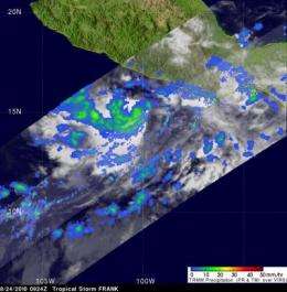
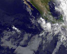
Tropical Storm Frank was wavering overnight in the eastern Pacific Ocean, just off the southwest Mexican coast, and recent satellite data has confirmed that convection has strengthened within the storm. GOES-11 captured an infrared image of Tropical Storm Frank early this morning and it appeared that the cloud cover was disorganized, but NASA's TRMM satellite looked "under the hood" of the storm and saw Frank powering back up.
At 11 a.m. EDT (8 a.m. PDT) Tropical Storm Frank's winds were near 65 mph. Frank was centered about 145 miles southwest of Acapulco, Mexico near 15.4 North and 101.4 West. That's also about 160 miles south of Zihuatanejo, Mexico. Frank was moving west-northwest at 7 mph and had a minimum central pressure of 994 millibars.
Although Frank's cloud cover appears somewhat disorganized in the infrared imagery from the Geostationary Operational Environmental Satellite known as GOES-11, NASA's Tropical Rainfall Measuring Mission (TRMM) satellite was able to peer into the storm and see the convection (rapidly rising air that forms the thunderstorms that power a tropical cyclone) was increasing. TRMM flew over Frank this morning, August 24 at 0924 UTC (5:24 a.m. EDT) and noticed deep convection around Frank's circulation center. TRMM's microwave imagery also saw tightly curved bands of thunderstorms wrapping around the center of Frank, and it appeared that they covered about 75 percent of an eye wall (towering clouds and thunderstorms around the open center of a tropical cyclone). Convection has even improved since then, indicating Frank is strengthening again.

Microwave satellite data (such as that that flies on TRMM) was also helpful in determining that Frank is not moving as quickly as previously believed. Frank is now moving west-northwest near 7 mph.
Frank is far enough away from the Mexican coast so that currently, there are no coastal watches or warnings in effect. Despite its distance from land, Frank's rainfall extends over land and is forecast to bring 2 to 4 inches of rainfall over the next several days to south-central and southwestern Mexico as it slowly moves northwest. Isolated maximum amounts of rain up to 8 inches are possible over the higher terrain, and flash floods and mud slides will also be possible.
Provided by NASA's Goddard Space Flight Center


