NASA satellite sees Tropical Storm Edzani becoming extra-tropical

Tropical Storm Edzani will soon be Extra-tropical Storm Edzani and NASA's Tropical Rainfall Measuring Mission or TRMM satellite noticed that as its changing, the storm's rains are all south of the system. Earlier today, January 13, Tropical cyclone Edzani was located approximately 785 nautical miles east-southeast of La Reunion Island in the Southern Indian Ocean, near 28.1 South and 68.0 East. Edzani had maximum sustained winds near 40 mph, so it is still hanging onto tropical storm status as it continues changing into an extra-tropical storm. Edzani has tracked southwestward at 14 mph (13 knots) over the past six hours.
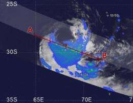
Animated infrared satellite imagery confirms what NASA and the Japanese Space Agency's TRMM satellite shows in Edzani - that the deepest convection and heaviest rainfall are confined to the southeast part of the storm. Both types of satellite images also show a fully exposed low-level circulation center. In addition, the latest image from the TRMM satellite shows that Edzani's shape resembles an egg more than a tire indicating that the storm is elongating and weakening.
TRMM captured Edzani's rainfall at 12:14 a.m. ET on January 13 and noticed that all of the rainfall in the storm is in the southern portion of the storm, falling at between .78 to 1.57 inches per hour.
Edzani is elongating because it's being affected by strong westerly winds. At the same time, cold air stratocumulus clouds are moving into the center of circulation helping it change to extra-tropical status (where the warm core air is replaced by cold air in the core of the storm).
Edzani is expected to continue transitioning into an extra-tropical storm and re-curve to the southeast in the next day, staying safely away from land areas.
More information: For more information about TRMM, visit: http://www.trmm.gsfc.nasa.gov/
Provided by NASA's Goddard Space Flight Center


