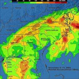
TRMM satellite mapped 'Ida the Low's' rainfall from space (w/ Video)

The Tropical Rainfall Measuring Mission satellite known as "TRMM" has the ability to measure rainfall from space, and assessed the heavy rainfall from last week's coastal low pressure area, formerly known as "Ida" that drenched the U.S. east coast.
Tropical storm Ida came ashore early on November 10, 2009, quickly weakened to a tropical depression and then became extratropical. A strong pressure gradient then developed between the remnants of Ida (a "coastal low pressure area") and an area of high pressure that had moved over New England. This resulted in strong winds blowing toward east coast shorelines that resulted in coastal flooding. Flooding tides in Virginia were near the values set by hurricane Isabel in 2003. The remnants of Ida also dropped heavy rainfall from the Gulf Coast to New Jersey resulting in flash floods.
Hal Pierce, a meteorologist who works on the TRMM science team at NASA's Goddard Space Flight Center in Greenbelt, Md. created a rainfall analysis that merged rainfall Data (3B42) from TRMM, other NASA satellites, U.S. Department of Defense satellites, National Oceanic and Atmospheric Administration polar-orbit satellites, and geostationary satellites. The analysis shows Ida's remnants resulted in large areas of very heavy rainfall with maximums in Alabama, North Carolina and Virginia. The analysis shows a maximum value over land of over 240 mm (~9.4 inches).
Heavy rain amounts (from satellites) and flood potential calculations (from a hydrological model) are updated every three hours globally with the results shown on the "Global Flood and Landslide Monitoring" TRMM web site pages.
Source: NASA/Goddard Space Flight Center


