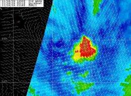
QuikScat and Aqua providing important data on Tropical Storm Anja

Anja has continued to weaken over the last 24 hours, and NASA's QuikScat satellite has confirmed that the once mighty Category 4 Cyclone is now a tropical storm in the southern Indian Ocean. Two instruments on NASA's Aqua satellite have also helped forecasters determine Anja's location and change of shape.
NASA's QuikScat satellite uses microwave technology to peer through a tropical cyclone's clouds, and actually read the speed of the rotating surface winds. In an overpass from space at 7:58 p.m. ET last night, November 18 (Nov. 19 at 0058 UTC), QuikScat noticed Anja's maximum sustained winds have dropped to 63 mph, making it a tropical storm.
Around that time, Anja's center was 560 miles east of Port Louis, Mauritius, near 22.4 degrees South latitude and 68.1 East longitude. Anja was moving south-southeast at 23 mph (20 knots). Anja is staying at sea and away from any landmasses, and poses no threat before it is expected to dissipate by the weekend.
Satellite imagery from NASA's Aqua satellite has helped forecasters determine where Anja's center is located, and how it has changed shape. Animated infrared imagery, such as that from NASA's Atmospheric Infrared Sounder (AIRS) instrument showed the system has become sheared and elongated toward the southeast. Another instrument on NASA's Aqua satellite, the Advanced Microwave Sounding Unit-B (AMSU-B), helped determine Anja's position using microwave technology when it flew overhead.
As Anja continues to weaken, its tropical storm-force winds don't have the extent they had yesterday. Today, November 18, tropical storm-force winds of 37 mph or higher extends out to 105 miles from Anja's center.
In addition to the wind shear that has been weakening Anja, sea surface temperatures are also decreasing as Anja continues to move toward the southeast. Sea surface temperatures are now below 26 degrees Celsius (78 degrees Fahrenheit) and are cooler farther southeast. To maintain intensity, tropical cyclones need sea surface temperatures of at least 80 degrees Fahrenheit.
Anja has now begun to speed up and is making a transition into an extra-tropical storm.


