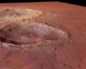
Impact Craters in Tyrrhena Terra

The High Resolution Stereo Camera (HRSC) on board ESA’s Mars Express obtained images of the Tyrrhena Terra region on Mars.
On 10 May 2007, the pictures of the region located at 18° South and 99° East were taken during orbit number 4294 with a ground resolution of approximately 15 metres per pixel.
The Sun illuminates the scene from the south-west (top-left in the image).
Tyrrhena Terra is part of the ancient, heavily cratered southern Martian highlands. The region is located north of Hellas Planitia, the largest impact basin on Mars. The image scene exhibits three impact craters, located at the eastern border of Tyrrhena Terra with Hesperia Planum.
The western part of the scene is dominated by a 35 kilometre-wide and approximately 1000 metre-deep impact crater with an extremely steep rim. The rim rises up to 400 metres above the surrounding plains.
The crater is surrounded by multiple layers of material ejected during the impact. These so called ‘ejecta blankets’ spread up to a distance of 50 kilometres around the crater.
Their round, lobate appearance hints at possible ice- and water-rich subsurface material.
The raised feature in the centre of the crater most likely originated from the elastic rebound of compressed subsurface material after the impact. This feature is called 'central peak' or 'central uplift'. This is comparable to what happens when a drop of water hits a puddle.
Another, 18 kilometre-long and approximately 750 metre-deep impact crater, in all likelihood a ‘double impact crater’, is located south of the large crater.
These ‘double impact craters’ develop when two objects, possibly part of the same fragmented object, hit the surface almost simultaneously.
The impact that formed the larger northern crater, which displays an intact crater wall, occurred after the double-impact crater was formed. The ejecta from this later impact has reshaped the double-impact crater.
The northern part has been filled by ejecta and the material is present even at the bottom of the crater, in the direction of the point of impact (towards the larger, neighbouring crater).
The colour scenes have been derived from the three HRSC colour channels and the nadir channel. The perspective views have been calculated from the Digital Terrain Model derived from the HRSC stereo channels. The anaglyph images were calculated by putting together data from the nadir channel and one stereo channel. The black and white high-resolution images were derived from the nadir channel which provides the highest level of detail.
Source: ESA


