ESA satellite guides polar explorers across disintegrating sea ice

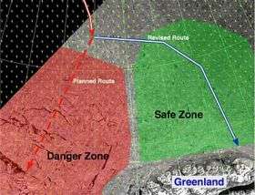
Two Belgian explorers currently nearing the end of a staggering 2 000 km trek across the Arctic Ocean were recently guided through hazardous conditions using observations from Envisat, as sea ice in the Lincoln Sea began to break up unexpectedly.
Throughout the Arctic Arc expedition, which marks the International Polar Year, Alan Hubert and Dixie Dansercoer have been collecting snow-depth data for ESA's CryoSat-2 mission. As seasoned polar explorers, they are used to dealing with the extremely harsh, dangerous and physically demanding conditions encountered during their three and a half-month expedition from Russia to Greenland via the North Pole. Extremely low temperatures, high winds and a few fractures or openings in the ice, called 'leads', are to be expected.
However, they recently faced a potential dangerous additional challenge as their expedition neared the Greenland coastline – an unanticipated chaotic break up of the sea ice in the Lincoln Sea, part of the Arctic Ocean. Apart from being dangerous, the disintegrating sea ice imposed another huge burden on the two explorers, who had no choice but to circumnavigate the open ice-free water leads.
When confronted with such challenges and critical decisions about the best way to proceed, it is comforting to note that Alain and Dixie could rely on logistical support based on data from ESA's Envisat satellite. A combination of all-weather ASAR (Advanced Synthetic Aperture Radar) sensor and optical MERIS (Medium Resolution Imaging Spectrometer) image data are routinely analysed by Leif Toudal Pedersen from the Danish National Space Centre (part of the Danish Technical University), in order to provide expert interpretation of the ice conditions and an invaluable synoptic view of changing ice conditions along the explorer's route.
With the aid of these satellite images, Leif has been able to help the expedition to try to avoid the rapidly disintegrating ice pack in the Robson Channel between Greenland and Ellesmere Island in the extreme north of Canada, and help steer the expedition to safer ice conditions modifying their route to shore further to the east.
"I noticed in satellite radar images that the Arctic Arc expedition was heading straight into very difficult and dangerous ice conditions, with large areas of thin ice and open water," says Leif Toudal Pedersen. "Luckily I was able to follow the changes in ice conditions and ice drift thanks to the daily coverage provided by the Envisat ASAR sensor, which provided a continuous source of information on the evolving ice conditions. Combined with an automatic data processing system and daily mosaics from the MERIS optical instrument, it helped me predict safe and unsafe areas in the sea ice and provide this crucial information to Alain and Dixie in field via the International Polar Foundation."
The Arctic Arc expedition is part of the International Polar Year 2007-2008. Alain Hubert and Dixie Dansercoer ‘stepped’ onto the sea ice off the coast of Siberia on 1 March 2007 and have since covered an amazing 1 600 km, each pulling a 130-kg sledge holding supplies and equipment. Along the way, these two intrepid explorers are contributing to the preparation of the CryoSat-2 mission, which is due for launch in 2009, by measuring snow depths at regular intervals. These in turn will be used by scientists to assess how well snow conditions can be predicted using existing climate models as well as inputs to methods for improving the accuracy of CryoSat-2 maps of sea-ice thickness.
Now on stable ice and with less than 50 km to go and clear views of Greenland in front of them the explorers are expected to reach the end of their long trek across the entire Arctic basin this week. Alain Hubert commented on 10 June, "We seem to have come through the boggy mass of the past few weeks in the Lincoln Sea, particularly where it narrowed. We can see now that the ice we are on is old ice again, and so more stable. What happened in the Lincoln Sea, I will never understand. But I think in any case that the worst of the problems are finally behind us and we can now look forward to the final part of our expedition with greater peace of mind."
The Arctic Arc expedition was originally planned to continue on to southern Greenland, but bad ice conditions have made progress slow, so a decision as to whether the expedition will continue or not will be made once the two explorers reach the mainland.
In the future, event better tools from space to monitor ice conditions are expected through the ESA GMES (Global Monitoring for Environment and Security) programme and the Sentinel satellites. All of the Sentinel satellites have been designed to meet the requirements of operational users. The Sentinel-1 SAR satellite series, in particular, is expected to provide rapid all-weather access to high-resolution ice charts over large areas and covering long time periods in support of shipping and ice-breaker services.
The experience of Alain Hubert and Dixie Dansercoer during their expedition seems to indicate that polar explorers also represent an, albeit small, additional group of users that will benefit from these new operational satellite developments at ESA.
Source: European Space Agency


