Colorado River streamflow history reveals megadrought before 1490

An epic drought during the mid-1100s dwarfs any drought previously documented for a region that includes areas of Arizona, Colorado, New Mexico, Utah and Wyoming. The six-decade-long drought was remarkable for the absence of very wet years. At the core of the drought was a period of 25 years in which Colorado River flow averaged 15 percent below normal.
The new tree-ring-based reconstruction documents the year-by-year natural variability of streamflows in the upper Colorado River basin back to A. D. 762, said the tree-ring scientists from The University of Arizona in Tucson who led the research team.
The work extends the continuous tree-ring record of upper Colorado streamflows back seven centuries earlier than previous reconstructions.
"The biggest drought we find in the entire record was in the mid-1100s," said team leader David M. Meko, an associate research professor at UA's Laboratory of Tree-Ring Research. "I was surprised that the drought was as deep and as long as it was.
Colorado River flow was below normal for 13 consecutive years in one interval of the megadrought, which spanned 1118 to 1179.
Meko contrasted that with the last 100 years, during which tree-ring reconstructed flows for the upper basin show a maximum of five consecutive years of below-normal flows.
The Colorado supplies water for cities and agriculture in seven western states in the U.S. and two states in northwestern Mexico. Los Angeles, Las Vegas, Denver, Phoenix, Tucson and Albuquerque are among the many cities dependent on Colorado River water.
The Intergovernmental Panel on Climate Change predicted in a recent report that the southwestern U.S. will become hotter and drier as the climate warms.
Co-author Connie A. Woodhouse said, "We have natural variability that includes this time in the 1100s. If we have warming it will exacerbate these kinds of droughts."
The newly documented droughts "could be an analogue for what we could expect in a warmer world," said Woodhouse, a UA associate professor of geography and regional development and dendrochronology.
Meko, who was asked by the California Department of Water Resources to pursue the research, said understanding more about natural variability in the Colorado is important to the region's water managers.
"Water managers rely on wet years to refill reservoirs," he said.
The team's research article, "Medieval drought in the upper Colorado River Basin," is scheduled to be published online in the American Geophysical Union's journal Geophysical Research Letters on May 24.
Meko and Woodhouse's co-authors are Christopher A. Baisan, a UA senior research specialist; Troy Knight, a UA graduate student; Jeffrey J. Lukas, of the University of Colorado at Boulder; Malcolm K. Hughes, a UA Regents' Professor of dendrochronology; and Matthew W. Salzer, a UA research associate. The California Department of Water Resources, the U.S. Geological Survey and the U.S. Bureau of Reclamation funded the work.
Just about a year ago, Woodhouse and Meko and colleagues published a continuous tree-ring record for the upper Colorado River Basin that went back to 1490, the longest record for the area until now.
Other paleoclimatic research had suggested that epic droughts occurred in much of the western U.S. during the Medieval Climate Anomaly of about 900 to 1300, a time when some parts of the world were warmer than now. In addition, tree-ring data from a large network of sites showed that the areal extent of drought in western North America peaked prior to 1400.
Meko, Woodhouse and their colleagues wanted to take a closer look at what happened in the upper Colorado River basin during that time.
For the record back to 1490, the scientists took cores from old, living trees and looked at the rings' tell-tale pattern of thick and thin that indicates wet years and dry years.
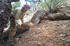
Extending the record further required an underutilized technique, the analysis of logs, stumps and standing dead trees, known as remnant wood.
Baisan said, "Everyone was surprised that we could do this."
Woodhouse said, "It's so arid that wood can remain on the landscape for hundreds of years. The outside of some of our remnants date to 1200, meaning the tree died 800 years ago."
The scientists took pencil-thin cores from the living trees and cross-sections of the remnant wood from 11 different sites. The researchers then pieced together the long-term record by matching up the patterns from the cores to those from the cross-sections.
Baisan said, "This is part of ongoing work to try to understand the climate system that creates these patterns. You need the basic data about what happened before you can ask questions such as 'Why were there 60 years of low-flow on the Colorado?"
The team's next step is collecting additional samples from the study sites and adding additional study sites in the upper Colorado River basin.
Source: University of Arizona


