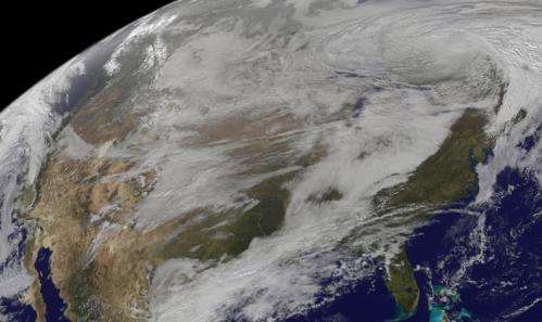
New satellite movie shows US pre-winter wintry outbreak

(Phys.org) —Three days of satellite imagery from NOAA's GOES-East satellite were compiled into an animation that showed the progression of the storm system that dropped snow and brought gusty winds to the Northern Rockies and Midwestern U.S. on Nov. 11 and 12.
NOAA's GOES-West satellite captured the movement of the pre-winter wintry storm from its location in a fixed orbit in space. GOES-West captures visible and infrared imagery of all weather over the western and central U.S. and Eastern Pacific Ocean. The GOES-West visible and infrared imagery from Nov. 10 to Nov. 12 at 17:30 UTC/12:30 p.m. EDT were compiled into a 21 second video made by NASA/NOAA's GOES Project at NASA's Goddard Space Flight Center in Greenbelt, Maryland.
To create the video and imagery, NASA/NOAA's GOES Project uses cloud data from NOAA's GOES-East and GOES-West satellites and overlays them on a true-color image of land and ocean created by data from the Moderate Resolution Imaging Spectroradiometer, or MODIS, instrument that flies aboard NASA's Aqua and Terra satellites. Together, those data created the entire picture of the storm and show its movement. After the storm system passes, the snow on the ground becomes visible.
NOAA's National Weather Service noted on Nov. 12 that the storm system moving across eastern Canada will bring lake effect snow across parts of the Great Lakes through Thursday. Behind the cold front, an Arctic air mass will bring much lower temperatures—in some cases 25 to 40 degrees below normal—across much of the northern and central U.S.
On Nov. 12 by 9 a.m. EST the main low pressure center of the wintry storm had moved northeast into southeast Ontario. As the cold front associated with the low pressure area was moving eastward into the Mid-Atlantic States an Arctic air mass stayed in place behind it, blanketing much of the northern and central U.S. In the Upper Great Lakes Region westerly to northwesterly winds blowing across the waters of the Great Lakes was causing some lake enhanced snowfall.
In a NOAA storm summary for the Northern Rockies to Upper Great Lakes on Nov. 12 at 10 a.m. EST, National Weather Service Forecaster Krekeler at the Weather Prediction Center in College Park Maryland noted: While the snow associated with the main storm has now ended...westerly to northwesterly winds on the backside of the low center will continue to bring lake enhanced snowfall to parts of the upper great lakes region over the next couple of days. Additional snowfall amounts between 4 and 8 inches is still possible with locally higher amounts, especially across the Upper Peninsula of Michigan.
The snowfall totals were impressive from the system. In Minnesota the highest total was 16.5 inches, recorded in Cambridge, Rush City and St. Augusta. Whitefish, Montana claimed 14.0 inches, while the highest total in North Dakota went to Bowman where 8.0 inches of snow fell, according to the National Weather Service. Downtown Rapid City, South Dakota claimed the state's highest snowfall at 8.5 inches. Further east, many areas in Wisconsin saw snow totals over a foot with the highest total at 26.0 inches in the town of Gile.
Powerful winds accompanied this winter-like storm. In Pike's Peak, Colorado a wind gust to 81 mph was recorded and a gust to 84 mph was noted in Snowbasin, Utah. Greybull, Wyoming noted a 66 mph gust, West Wendover, Nevada had a gust to 67 mph, and Driggs, Idaho reported a 68 mph gust. Winds gusted over 50 mph in various areas in Montana, Missouri and Oklahoma.
NOAA's GOES satellites provide the kind of continuous monitoring necessary for intensive data analysis. Geostationary describes an orbit in which a satellite is always in the same position with respect to the rotating Earth. This allows GOES to hover continuously over one position on Earth's surface, appearing stationary. As a result, GOES provide a constant vigil for the atmospheric "triggers" for severe weather conditions such as tornadoes, flash floods, hail storms and hurricanes.
Provided by NASA


