Cleaning the Chesapeake Bay from space

(PhysOrg.com) -- A pilot test of an innovative use of new remote sensing technologies to aid the Chesapeake Bay cleanup begins this year in Talbot County, Md., on the Bay's Eastern Shore.
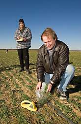
Greg McCarty, a U.S. Department of Agriculture (USDA) soil scientist, and Dean Hively, now a visiting U.S. Geological Survey physical scientist, merged remote sensing, field sampling, and farm program records to judge the effectiveness of winter cover crops in controlling farm nitrogen and phosphorus losses to the Bay.
McCarty and Hively lead an interagency research team that works closely with the Maryland Department of Agriculture. McCarty is at the Agricultural Research Service (ARS) Hydrology and Remote Sensing Laboratory (HRSL) in Beltsville, Md. ARS is USDA's principal intramural scientific research agency.
Cover crops—mostly rye, barley, and wheat—are a principal tool in Maryland for controlling nitrogen and phosphorus flows to the bay. The crops catch excess nitrogen and phosphorus left over from fertilizers and manures used to grow corn, soybean or other summer crops.
In a 4-year study using this combination of tools, McCarty and Hively showed that, of the three major cover crops, wheat is by far the least efficient at taking up nitrogen, due to its slow fall growth. Yet 60 percent of the land planted to cover crops is in winter wheat. Maryland pays farmers part of the costs of planting cover crops, with a premium for early-planted and non-wheat crops.
The pilot project will allow the Talbot County soil conservation district office to evaluate underperforming fields to plan for improved implementation in the coming year.
The scientists are developing software to summarize the data, by county and by watershed, to produce reports for Chesapeake Bay Watershed partners, including county, state, federal and other agencies.
This is all part of a feedback system that will lead to annual adjustments in federal and state conservation program implementation strategies.
With success, the project will be scaled up to each of Maryland's 24 soil conservation districts statewide.
More information: Read more about this research in the August 2010 issue of Agricultural Research magazine.
Provided by USDA Agricultural Research Service


