Puffin 'sat-nav' solves mystery of feeding flight paths
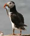
Cutting edge technology is shedding light on the daily flight paths of puffins around the Farne Islands and providing clues that could be vital to the seabirds' survival.
Over the last year, scientists from Newcastle University have used the technology to build up a picture of where the puffins are heading for when they take off from the Farne Islands each day. This shows that they are making a beeline for feeding ‘hotspots’ 20 miles out to sea.
Along with their established and protected breeding grounds on the islands, these hotspots may be important areas to conserve in order to ensure the puffin’s future survival.
Since last year - after a dramatic 30 per cent decline in puffin numbers had been recorded in 2008 - a team of researchers have been working with National Trust wardens on Brownsman Island and deploying a whole raft of puffin technology to track their every move.
Dr Richard Bevan from Newcastle University, who is leading the research, said: “The technology has come into its own here on the Farne Islands. Knowing where these seabirds go to feed is a vital factor in their survival.
“For the first time we can accurately pinpoint where puffins, kittiwakes and other seabirds are going to forage, work towards conserving and monitoring these feeding grounds and securing the future of the birds themselves.”
Up until now a great deal has been known about puffins’ breeding behaviour on the islands but very little about where they went to forage and how they got there. Even less was know about where they went when they left the islands in summer for the long winter ahead at sea.
GPS loggers, using the latest sat-nav technology, have been fitted to 12 birds to follow their fishing expeditions out from the islands and back. Results reveal that they now appear to be travelling about 20 miles out from the islands - whereas they were previously thought to head anything up to 60 miles away.
One of the favoured feeding areas seems to be the Farnes Deep, an area of deeper water about 20 miles south east of the islands. Some puffins favour a quick out and back trip, possibly to stock up on sand eels for their ever-hungry chicks. Others take a longer, more circuitous route - with several shorter foraging bouts interspersed with short flights and periods resting on the surface of the water.
Time-depth recorders, which monitor the diving behaviour of the birds, were temporarily glued to the feathers of 16 puffins to gain an idea of how often they dive, how long they dive for and to what depth. Puffins were thought to be diving up to 25 metres in previous years, but now they are only going down an average of 4-5 metres.
And finally, in 2009 tiny geo-locators were fitted to the leg rings of eight birds to try and solve the mystery of where puffins disappear to in the winter. Two have come back so far and the data are waiting to be extracted by research collaborators in the British Antarctic Survey.
David Steel, National Trust Head Warden on the Farne Islands, said: “All the signs seem to be that the puffin numbers are bouncing back slowly. There’s plenty of food about for them and despite the harsh winter they arrived on the islands earlier this year, and their chicks are doing fine.”
Provided by Newcastle University


