Typhoon Mirinae is already scaring Philippine residents before Halloween

Another typhoon in the northern Philippines really is something to be scared about, and Mirinae is expected to make landfall there in the mid-morning hours on Halloween, October 31. Mirinae will be the fourth major storm to hit the Philippines in one month bringing more rain to an already flood-weary region.
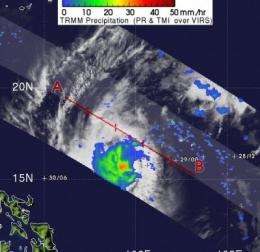
NASA's Tropical Rainfall Measuring Mission (TRMM) satellite is already hard at work analyzing rainfall, to provide meteorologists with an idea of what can be expected when the storm hits.
NASA and the Japanese Space Agency's TRMM satellite flew over Typhoon Mirinae on October 29 at 1018 UTC and measured its rainfall from space. Mirinae had moderate rainfall between .78 to 1.57 inches per hour around its center. TRMM images are made at NASA's Goddard Space Flight Center in Greenbelt, Md. and take some ingenuity to create. A typical TRMM rainfall image combines the infrared and visible channels overlaid with a precipitation analysis from the TRMM Microwave Imager and PR instruments.
The government of the Philippines isn't waiting for the storm to arrive. It is already sending evacuating people and sending in relief supplies.
On October 29 at 11 a.m. EDT (11 p.m. Asia/Manila Time), Mirinae had maximum sustained winds near 90 knots (104 mph or 167 km/hour). Mirinae's center was about 480 nautical miles east of Manila, near 15.6 North and 128.7 East. It was still moving west near 12 knots (14 mph) and kicking up dangerous waves as high as 31 feet high.
The environment that Typhoon Mirinie is in is enabling the storm to maintain intensity. Mirinae is in an area of light-to-moderate vertical wind shear. Strong wind shear (winds blowing at different levels of the atmosphere) can tear a storm apart, but that's not the case in the Philippine Sea where Mirinae is currently located. In addition, the sea surface temperatures remain warm there, in excess of 28 degrees Celsius (82 Fahrenheit). In order for a typhoon or hurricane to maintain intensity, it needs sea surface temperatures as warm as 80F.
Current forecasts expect Mirinae's center to make landfall sometime around 8 a.m. Asia/Manila time on October 31, and after 12 hours, the storm is expected to move into the South China Sea.


