Transcending boundaries in Louisiana watershed management

Often local and regional regulations impact the natural environment beyond the jurisdiction for which they were developed. Scientists in LSU's College of the Coast & Environment are analyzing Louisiana's patchwork of regulations to get a big picture view of how they are influencing current conditions in the coastal watershed. This research is part of the Louisiana Watershed Initiative, or LWI, and will assess how to improve deficiencies in Louisiana's approach to floodplain management and community planning across all levels of government.
According to Thomas Douthat, principal investigator on the project and assistant professor in the LSU Department of Environmental Sciences, "Flooding doesn't affect just one house or just one part of a system. If you want to address it systematically, you can't do that from a single jurisdictional perspective."
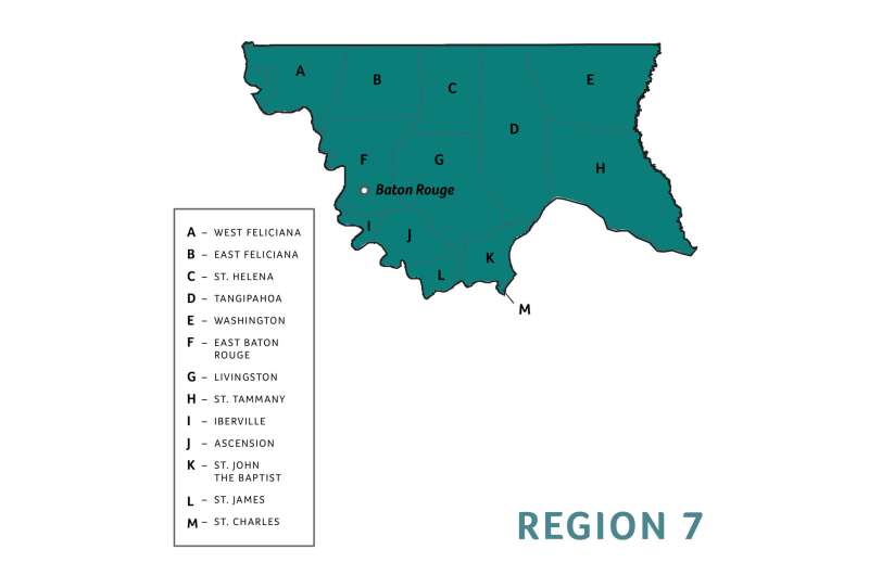
LWI is a statewide, watershed-based floodplain management program that was established in the aftermath of two historic rain events Louisiana experienced in March and August 2016. These floods produced trillions of gallons of rainwater and impacted 56 of Louisiana's 64 parishes. LWI has identified eight watershed regions as a starting point to coordinate efforts among parishes and distribute project funds. Research from Douthat's team will cover all of Region 7, a loose triangle that encompasses all the parishes between West Feliciana, Washington and St. Charles, including the Greater Baton Rouge area.
Graduate student Lindsey Lamana from Port Barre, Louisiana, and undergraduate Victoria Nguyen from Baton Rouge are working with Douthat to gather and tabulate Region 7's data in the following categories: transportation, flood control, emergency response, infrastructure development and environmental conservation. They want to understand whether these regulations are working synergistically across jurisdictions to improve environmental conditions or whether they conflict with one another in a way that is harmful to the people and ecosystems within the watershed.
Douthat's background as a lawyer and urban planner enables him to see the bigger picture—mapping regulations and best practices in the region that can then be compared to others. At the conclusion of his team's network analysis and planning evaluation, they will provide data-driven visualization tools to the Capitol Region Planning Commission that will illustrate the network within which the various local and regional regulatory bodies and some private sector organizations operate. This framework will form a foundation from which they can identify existing patterns of collaboration and build upon them in order to further reduce negative impacts on the environment, property damage and flooding and increase resilience and sustainability.
"We can use the approach of network analysis and planning evaluation, which we call NAPE, not only to address watershed governance, as we have done in this study, but also to address coastal change, regional pollution management and other areas that involve multi-scalar and multi-thematic environmental planning challenges," Douthat said.
Preliminary results show that more developed regions, like East Baton Rouge Parish, have more robust networks that are working together whereas regulatory bodies in rural areas are more isolated.
"The main thing I've found so far is that parishes usually interact within their parish instead of outside their parish. And, rural areas are less connected to urban areas as well because they have less capacity. So, for the Louisiana Watershed Initiative, I can see the need for some type of entity to help the different parishes coordinate with each other," Lamana said.
According to Nguyen, who is a junior in the Coastal Environmental Science program, "Working on this project opened a whole new door for me in understanding environmental regulation and how it applies to my state—to Louisiana. It applies to everything—how we live from day to day, so this really fueled my interest in environmental policy analysis."
Provided by Louisiana State University


