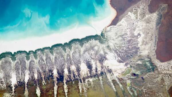
Orbital snaps reveal Roebuck Bay's tidal movements

A photo of Roebuck Bay just south of Broome, snapped by a curious astronaut on the International Space Station, has called into question the origin of some of the region's highly-unusual parallel tidal creeks.
Tidal creeks in the Kimberley are formed by huge tides—in Broome the spring tide ebbs and flows more than nine metres in about 12 hours.
This completely submerges some of the mangrove trees which are adapted to growing in these conditions.
The aqua-blue area in this photograph shows Roebuck Bay seawater, and the margin of white between this and the dark green fringe of mangroves shows the tide is not completely in.
When the sea water floods relatively flat land, it forms substantial saltwater creeks when it flows rapidly out again, depositing salty white mud.
You can see this white mud between the mangroves and the aquamarine sea, and also in the empty creek bottoms.
These creeks typically take a meandering tree-like (or dendritic) form, like the creek system you can see the top of the pale area in this photograph.
This is in marked contrast to the roughly-parallel creeks which show up as white feathery structures on the left of the image, eleven of them penetrating the red soils and yellow-green pastures of Roebuck Plains Station.
UWA geologist Dr Karl-Heinz Wyrwoll agrees with NASA's interpretation of the feather-like formations, describing them as channels between former desert sand dunes that were inundated when sea levels rose to their present height about seven thousand years ago.
However, geomorphologist Dr Ian Eliot says these would have been washed away when sea levels were approximately two metres higher than today.
He says the unusual parallel dunes are tidal channels formed by rapid water flows.
Both scientists refer to Google Earth images of country further inland to back up their assertions.
Dr Wyrwoll says similar dunes he has studied near Derby and the Fitzroy Valley have been active several times in the past 20,000 years, pointing to drier periods.
During these times the winds would have gradually moved the dunes as there was not enough covering vegetation to keep the sand stable.
The sea simply followed the pattern of these dunes in Roebuck Bay, the tides forming creeks as they flowed between the ridges, he says.
Both scientist agree that the sea has flooded larger parts of Roebuck Plains at some stage during the last few thousand years, obliterating the old desert dunes.
Provided by Science Network WA
This article first appeared on ScienceNetwork Western Australia a science news website based at Scitech.


