Peering through Titan's haze

This composite image shows an infrared view of Saturn's moon Titan from NASA's Cassini spacecraft, acquired during the mission's "T-114" flyby on Nov. 13, 2015.
The spacecraft's visual and infrared mapping spectrometer (VIMS) instrument made these observations, in which blue represents wavelengths centered at 1.3 microns, green represents 2.0 microns, and red represents 5.0 microns. A view at visible wavelengths (centered around 0.5 microns) would show only Titan's hazy atmosphere. The near-infrared wavelengths in this image allow Cassini's vision to penetrate the haze and reveal the moon's surface.
During this Titan flyby, the spacecraft's closest-approach altitude was 6,200 miles (10,000 kilometers), which is considerably higher than those of typical flybys, which are around 750 miles (1,200 kilometers). The high flyby allowed VIMS to gather moderate-resolution views over wide areas (typically at a few kilometers per pixel).
The view looks toward terrain that is mostly on the Saturn-facing hemisphere of Titan. The scene features the parallel, dark, dune-filled regions named Fensal (to the north) and Aztlan (to the south), which form the shape of a sideways letter "H."
Several places on the image show the surface at higher resolution than elsewhere. These areas, called subframes, show more detail because they were acquired near closest approach. They have finer resolution, but cover smaller areas than data obtained when Cassini was farther away from Titan.
Near the limb at left, above center, is the best VIMS view so far of Titan's largest confirmed impact crater, Menrva (first seen by the RADAR instrument in PIA07365). Similarly detailed subframes show eastern Xanadu, the basin Hotei Regio, and channels within bright terrains east of Xanadu.
Due to the changing Saturnian seasons, in this late northern spring view, the illumination is significantly changed from that seen by VIMS during the "T-9" flyby on December 26, 2005. The sun has moved higher in the sky in Titan's northern hemisphere, and lower in the sky in the south, as northern summer approaches. This change in the sun's angle with respect to Titan's surface has made high southern latitudes appear darker, while northern latitudes appear brighter.
-
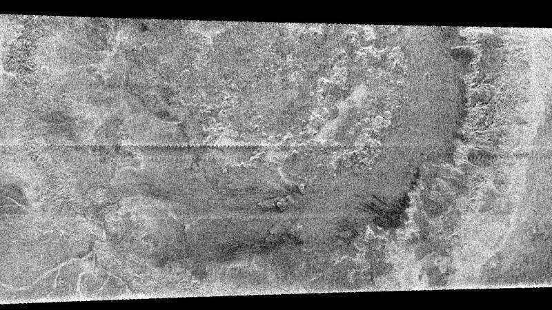
A huge annular feature with an outer diameter of approximately 440 kilometers (273 miles) appears in this image taken with Cassini's Titan radar mapper. It resembles a large crater or part of a ringed basin, either of which could be formed when a comet or asteroid tens of kilometers in size slammed into Titan. This is the first impact feature identified in radar images of Titan. The surface of Titan appears to be very young compared to other Saturnian satellites. In Titan's case, debris raining down from the atmosphere or other geologic processes may mask or remove the craters. The pattern of brightness suggests that there is topography associated with this feature; for example, in the center of the image there appear to be mounds each about 25 kilometers (15 miles) across. Since they are dark on their lower edges that face away from the radar and bright on the opposite face, they must be elevated above the surrounding terrain. Credit: NASA/JPL-Caltech/ASI -
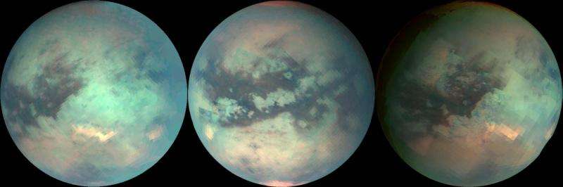
The three mosaics shown here were composed with data from Cassini's visual and infrared mapping spectrometer taken during the last three Titan flybys, on Oct. 28, 2005 (left image), Dec. 26, 2005 (middle image), and Jan. 15, 2006 (right image). These false-color images were constructed from images taken at the following wavelengths: 1.6 microns (blue), 2.01 (green), and 5 microns (red). The viewing geometry of the December flyby is roughly on Titan's opposite hemisphere from the flybys in October and January. There are several important features to note in the images. The first is that the south polar cloud system was very bright during the December flyby, while during the October and January flybys, it is barely visible, indicating that the atmosphere over Titan's south pole is very dynamic. In the December (middle) mosaic, a north polar hood that is bright at 5 microns is visible. Its composition is unknown. The north polar hood is barely seen in the October (left image) and January (right image) data. Visible in the October and January images just south of the equator is Tui Reggio, a region nicknamed the "chevron." This region is very bright at 5 microns and is among the brightest features on Titan at that wavelength. Tui Reggio is thought to be a surface deposit, probably of volcanic origin, and may be water and/or carbon dioxide frozen from the vapor. The January flyby data show that the western margins of Tui Reggio have a complex flow-like character consistent with eruptive phenomena. Credit: NASA/JPL/University of Arizona
Provided by NASA


