Unlocking the secrets of the Ross Ice Shelf

The Ross Ice Shelf is much like the Rosetta Stone. The historic stone was inscribed in three different scripts; each telling the same story but in a different tongue. When matched together the information was enough to allow scholars to decode an ancient language. The Rosetta Project in Antarctica also brings together three different 'scripts', but in this case they written by three Earth systems; the ice, the ocean and the underlying bed each have a story to tell. Mapped together these three systems can be used to unlock the mysteries of Antarctic ice history in this region and help us to develop models for predicting future changes in Antarctic ice.
The multi-institutional project is multi-disciplinary in nature and takes advantage of the recently commissioned IcePod integrated ice imaging system as the main science platform. IcePod is package of geophysical instruments packed into a 9 ft. container and loaded onto the large LC130 transport planes supporting science in the polar regions. Flown by the US Air National Guard these planes are the workhorses of the science program. A unique 'arm' that fits into the rear side-door of the plane is used to attach the IcePod outside the aircraft, allowing it to be used on both dedicated missions and flights of opportunity.
IcePod's instruments include two radar to image through the ice, lidar to measure to the ice surface, cameras for surface images, and a magnetometer to better understand the tectonics and origin of the bed below the ice shelf. Together with the IcePod instruments the project will use two separate gravimeters in order to develop a bathymetric map of the seafloor under the ice shelf. Gravity is a critical data piece in this project as the radar is unable to image through the water under the ice shelf.
The Ross Ice Shelf is a thick slab of ice that serves to slow and collect ice as it flows off the Antarctic peninsula. Ross is the largest of the Antarctic ice shelves moving ice at rates of 1.5 to 3 meters/day. Somewhat triangular in shape, it is bounded by the West Antarctic ice sheet on the west, the East Antarctic ice sheet on the east, and the Ross sea along the front.
This three year project involves 36 separate flights in a two season field campaign. The first field season is underway now, and will focus on building the larger framework for the dense 10 km spaced grid of flights that is planned for the following season. As each day's flights are logged they are being posted on our interactive website. You can follow our campaign by linking directly to this data portal to watch the grid develop. You can select the project proposed flight plan (v9) on the Data Map to get a complete look at the project plan. The end product will be a dense grid of flightlines evenly spaced and crossing with regular tie points.

First flights included two survey lines across the ice shelf. The most southern of the two lines was flown by IcePod in 2014 during commissioning flights, and by the NASA IceBridge project in 2013. These two flights provide a calibration line for the system. The northern line is the first new line for the project. The map also shows a small test flight for the equipment and a line up to South Pole that was a piggy back flight with another mission of the plane.
You will note that flights originate from McMurdo so there is a dense radiating line from the base. Minna Bluff is a prominent volcanic promontory that sticks out close to MCM. The bluff was first identified by Capt. Scott in 1902 and is mentioned often in Antarctic exploration history.
-
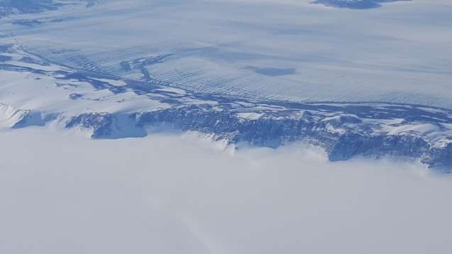
Flying up from the Ross Ice Shelf to cross the Transantarctic Mountains on the flight to South Pole. The Transantarctic Mountains are a stunning contrast to the flat surface of the Ross Ice Shelf. With peaks that reach upwards of 4000m they act like a zipper stretching across the continent for over 3500 kms connecting two very different sections of the Antarctic continent. Credit: N. Brady -
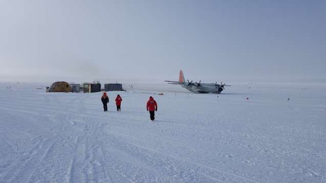
On the flight to the South Pole the LC130 hercules aircraft is the rear right parked at the edge of the skiway. The icePod is on the far side the South Pole station. Team members Kirsty, Tej and Fabio are heading towards the South Pole passenger terminal waiting to reboard. Credit: N. Brady
More information: Interactive Rosetta flight tracking instrument: pgg.ldeo.columbia.edu/projects/rosetta/
Provided by Earth Institute, Columbia University


