Scientists develop four-dimensional simulation of Fife coastline
A new four-dimensional interactive display – offering a bird's-eye view of the Fife coastline – has been developed by Abertay scientists.
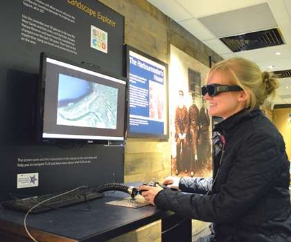
The Fife Landscape Explorer (FLEX) at the Harbourmaster's House in Dysart, has been designed to help local people get a better understanding of the sustainability issues affecting their daily lives.
The coastal region around St Andrews has been affected by rising sea levels and frequent severe storm events over recent years, and this technology will help the local inhabitants make informed decisions about how best to protect the land against further damage.
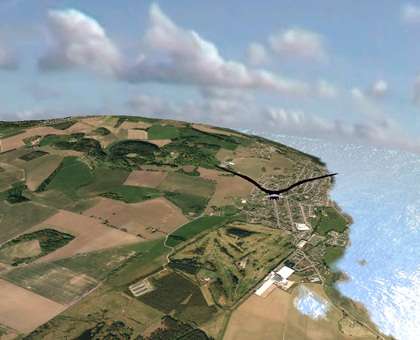
Visitors to the Harbourmaster's House can don 3D glasses and – using FLEX – 'fly' above the iconic seafront between St Andrews and Tayport.
They can also venture into the fourth dimension because the display shows the coastline as it was in the past, how it has evolved over the last century, and how it is predicted to look in the future.
Dr John Isaacs from Abertay University explains:
"Often, the people most affected by floods and extreme weather events are unable to make informed decisions about how best to adapt to them. This is generally because they don't have any means of fully understanding the complex interactions at play between the environmental, social and economic factors that are involved, so are unable to see what all the consequences of the decisions they – and other stakeholders – make will be.
"The tools to support the decision-making process are also usually dominated by the perceptions of the 'expert' decision-makers - like planners, architects and design engineers - so public consultation is usually only carried out using simple 2D plans or static 3D images, which don't really give people an idea of what the environment actually looks like.
"So we created a 3D virtual environment which uses realistic scenarios that enable stakeholders to be immersed in the affected area so that they can immediately realise what it is like to be present during a major storm event."
The Fife Coast & Countryside Trust's Business Manager Simon Phillips added:
"The system offers something for everyone. Children will enjoy the experience of flying around one of the most iconic stretches of Scottish coastline – including the world-famous Old Course and West Sands.
"But there's also a host of more sophisticated options to enhance the display, showing information on everything from local nature reserves to protected wetlands and Sites of Special Scientific Interest (SSSIs).
"We're confident this will add even more depth to the public's understanding of this important landscape, and we'd encourage everyone to visit the Harbourmaster's House and 'take to the air'."
The display was part-funded through the SUSCOD project (Sustainable Coastal Development in Practice), part of the INTERREG IVB North Sea Region Programme, which aims to make the North Sea Region a better place to live, work and invest in.
It draws on a wealth of information, including data from the Scottish Environment Protection Agency (SEPA) and even World War II reconnaissance photographs taken by the Luftwaffe.
Provided by University of Abertay Dundee


