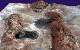
Fold mountains slip on soft areas

The Zagros Mountains are well researched from a geological perspective. However, scientists at the ETH Zurich have now used computer simulations to demonstrate for the first time how it came about that mainly folds with almost constant wavelengths of 14 kilometers were formed.
The Zagros Mountains in Iran, which are around 1,500 kilometres long, formed only in the past five million years. Rich oil reserves, huge salt deposits that are rising up from the subsurface and emerging as salt glaciers as well as their intensive folding make these mountains unique in the world. The Zagros Mountains are characterized in particular by relatively regularly recurring folds that have a uniform appearance. Up to now, geologists were not able to explain this geological phenomenon. But now Boris Kaus, an assistant professor at the Institute of Geophysics at ETH Zurich, has solved the mystery.
Making mountains in a computer model
Kaus, in collaboration with postdoc Philippe Yamato and researchers from Paris and Zurich used computer models to examine the emergence of the fold mountains and their rock properties over geological periods. The Zagros Mountains were particularly suitable as they are one of the most thoroughly examined mountain ranges in the world. The geology of the mountains is well researched thanks to subsurface drilling and seismic profiles.
The scientists attempted to use their models to imitate the geological structures that have developed over millions of years. They wanted to find out how the special spatial distribution of the folds with a wavelength of around 14 kilometres developed and why the layers of rock were mainly folded rather than thrust over each other.
Jura faults instead of Zagros folding
However, the scientists did not succeed in reproducing the folds using traditional models and parameters at first. The thrusts that kept forming on the computer screen looked like those found in the Jura. The Jura and Zagros Mountains are similar in that both developed during what is known as the Alpine orogeny and are thus relatively young in geological terms. Both mountain ranges also have salt deposits at the base of the rock layers. The overlying rock layers of both mountain ranges started to slip on the salt layers as a result of tectonic forces. The layers of rock in the Zagros were folded, while most layers in the Jura were thrust on top of each other.
Thrusts seem to be easier to imitate using traditional methods, because the researchers had to vary all of the parameters and conduct between ten and twenty thousand simulations before they managed to replicate the characteristic folds of the Zagros Mountains. It was not until they included the individual rock sequences in more depth in their models that they succeeded in recreating the Zagros Mountain folds.
Up to now, traditional models generally viewed the rock sequences as brittle. However after all of the unsuccessful trials, Kaus and his team then took more differentiated rock sequences into account in their models, ranging from rocks with varying hardness to soft, easy-to-deform rocks. This approach showed that not just the salt horizon but also other rock layers acted as slip planes. Contrary to the assumptions made to date, it became apparent that each individual rock layer influences the folding process.
The scientists also came up with a new method that can be used to derive the wavelength of the folds depending on the material parameters of the rocks quickly and without the need for lengthy calculations.
Mountains formed under water?
With the new method, the researchers demonstrate that mainly two parameters control the folding process and the wavelength of the folds. The flowability of the soft rock layers and the so-called angle of friction, which describes the brittleness of the rock. The angle of friction for hard, dry rock is around 30 degrees. In this case, thrusts result instead of folds. According to the researchers’ findings, the angle of friction has to be around 5 degrees in order to create the Zagros folds with their wavelength of 14 kilometers. «That is a surprising result and a strong indication that there was high fluid pressure when the mountains were formed», says Kaus. This means that the rocks were heavily permeated by water. For this reason, the researchers assume that the process of forming the mountains commenced either when the rock and sedimentary layers were still covered by seawater or that there must still have been a very large amount of water present in the rock.
More information: Yamato P, et al. : Dynamic constraints on crustal-scale rheology of Zagros fold belt, Iran, Geology (2011) Vol 39. No 9. p. 815-818. doi:10.1130/G32136.1
Provided by ETH Zurich


