NASA Sees Santa Barbara Wildfires

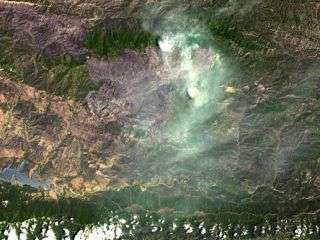
This image shows the Zaca fire, which continues to burn in the Los Padres National Forest near Santa Barbara, Calif. The image was acquired by ASTER on Aug. 7, 2007.
The fire started more than a month ago, on July 4, and has burned 69,800 acres. The fire remains in steep, rocky terrain with poor access. The continued poor access makes containment difficult in the wilderness area on the eastern flank.
So far only one outbuilding has been destroyed; more than 450 homes are currently threatened. Over 2,300 fire personnel, aided by four air tankers and 15 helicopters, are working to contain this massive fire. Full containment is expected on Sept. 1.
With its 14 spectral bands from the visible to the thermal infrared wavelength region, and its high spatial resolution of 15 to 90 meters (about 50 to 300 feet), ASTER images Earth to map and monitor the changing surface of our planet, and is one of five Earth-observing instruments launched Dec. 18, 1999, on NASA's Terra spacecraft.
The instrument was built by Japan’s Ministry of Economy, Trade and Industry. The broad spectral coverage and high spectral resolution of ASTER provides scientists in numerous disciplines with critical information for surface mapping, and monitoring of dynamic conditions and temporal change.
Source: NASA


