Rosetta's view of Earth
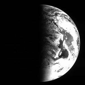
After skimming by the Earth at just 1954 km on 4 March 2005, Rosetta turned its Navigation Cameras back towards our home planet and recorded a series of black and white images.
These images were recorded by Navigation Camera 1 between 12:47 and 13:08 UTC, 5 March, with an integration time of between 0.01 and 0.05 seconds. The pictures show a field of view (FoV) of 4 degrees x 4 degrees.
At this time, Rosetta was flying away from the Earth having completed the closest-ever fly-by performed by an ESA mission the day before. On the bottom is Antarctica and above that South America can be seen. The coast lines are best visible in the first image.
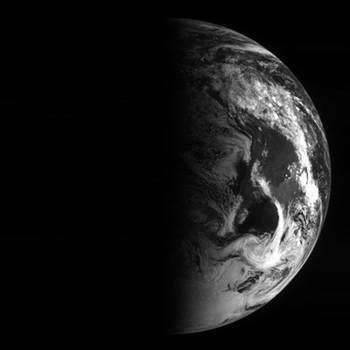
This image was recorded by Navigation Camera 1 at 12:47 UTC with an integration time of 0.02 second. This image is 1024 x 1024 pixels, but only the inner 820 x 820 pixels represent the Navigation Camera image. The view covers a field of view (FoV) of 4 degrees x 4 degrees. At this time, Rosetta was flying away from the Earth having completed the closest-ever fly-by performed by an ESA mission the day before. Credits: European Space Agency, ESA


