Endangered turtles' trek along ocean currents revealed by satellite
The site where Europe's spacecraft are launched into orbit, the Atlantic shoreline of French Guiana, is also the starting point for another hardly less remarkable journey: the epic migration of the critically endangered leatherback turtle.
Scientists have been using tracking sensors to follow the long treks of individual leatherbacks, then overlaying their routes with sea state data, including near-real time maps of ocean currents gathered by satellites including ESA's ERS-2 and now Envisat.
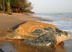
These giant reptiles - known to reach 2.1 metres in length and weigh in at 365 kg - briefly come ashore to lay their eggs on beaches across French Guiana and neighbouring Suriname, the turtles' last remaining major nesting sites in the Atlantic Ocean. Around nine weeks later the hatchlings emerge en masse and head into the sea, one day to return when they reach maturity and lay eggs themselves.
However each turtle's return is by no means certain. While in open water the turtles have been known to dive as deep as 1,230 metres in search of food, most of the time they do not venture deeper than 250 metres down, leaving them vulnerable to the hooks of longline fishermen – hundreds of thousands of such hooks are deployed daily across the Atlantic.
A paper was recently published in Nature summarising the work done so far in tracking leatherbacks through the Atlantic, submitted by a team of researchers from France's National Centre for Scientific Research in Strasbourg, neighbouring Louis Pasteur University, the French Guiana Regional Department of the Environment and the company Collecte Localisation Satellites (CLS) in Ramonville, specialising in satellite-based systems for location-finding, data collection and Earth Observation.
Pacific leatherbacks follow narrow migration corridors. Researchers hoped that if their Atlantic counterparts acted in the same way then fishing could be restricted across these zones.
Starting in 1999 individual turtles were tracked using the CLS-run Argos system, based on radio-emitting tags whose position can be tracked worldwide to a maximum accuracy of 150 metres. Six American NOAA spacecraft currently carry Argos receivers, with ESA's MetOp series due to join the system following their initial satellite launch next year.
The turtles' tracks were then overlaid with maps of sea level anomalies obtained by merging data with the radar altimeter aboard ESA's ERS-2 with another aboard the NASA-CNES satellite TOPEX-Poseidon.
ERS-2, like its successor Envisat, is part of the select group of satellites equipped with a Radar Altimeter (RA) instrument. By firing thousands of radar pulses off the surface of the sea every second extremely precise ocean height measurement is made possible. Height anomalies detected by this type of sensor are often indicators of the presence of ocean currents and eddies: warm currents can stand up to a metre above colder waters.
By merging multiple radar altimeter results together, the result is a more frequent and higher resolution measurement of sea level anomalies than any one spacecraft could achieve. For example, now that ERS-2's global mission is over, results from Envisat's RA-2 instrument are being combined with similar data from the joint French-US Jason spacecraft and the US Navy's GFO.
Unlike their Pacific relations, the Atlantic leatherbacks do not follow narrow migration corridors but disperse widely - to begin with, the leatherbacks carry out long nearly straight migrations either to the north or to the Equator, swimming across currents as they encounter them. One made it to within 500 km of West Africa before turning back, another came close to Nova Scotia.
Full story can be found here.


