Improving Wine With Satellites
The wine harvest has begun in many regions of Europe. Will it be a vintage year, what will quantities be like? Every vineyard owner has their own idea. But specialist engineers and administrations already have a comprehensive view produced using satellite observations.
EuroNews has gone to French and Italian vineyards to find out more.
For centuries Europe has been one of the world's foremost wine producers. There are a great variety of wines, often produced on small properties with practices handed down from generation to generation. Methods can still be largely empirical, costly and some times inappropriate in a context of strong international competition.
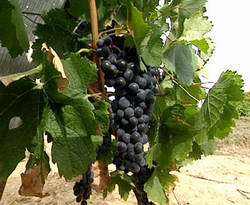
EuroNews met quality control engineers, like Hilde Chevillot in the South of France, who regularly measure the size of leaves, check for the smallest sign of disease, and evaluate the degree of maturity of the grapes.
This terrain-based approach provides valuable information. Entered into computer databases, it allows local analyses. But in 2001 the European Space Agency (ESA) initiated Bacchus, a technology and research pilot programme to increase precision and to obtain an overview. Now managed as a consortium, it is backed by the European Commission and involves companies, research institutes and wine growers' organisations through out Europe.
French agronomist Damien Rolland fully appreciates the imagery and information provided by several satellites, such as Spot-5 and Envisat.
"Within a single Controlled Origin Denomination area, there may be several hundred small plots of vines. The advantage of satellites over aerial reconnaissance is that the information is uniform in nature and provided at regular intervals. We can precisely calculate the acreages involved, detect un-authorised plantations, and obtain many details about the surfaces that are cultivated."
At offices in ESA's European Space Research Institute (ESRIN) establishment in Frascati, a region near Rome well known to wine connoisseurs, Luigi Fusco oversees the Bacchus project.
"Earth observation satellites now have remote sensing instruments operating in a variety of modes, optical, radar, infra-red. The scientific data that can be extracted is considerable. Depending on the satellite's resolution, we can obtain data on precise soil composition, the slopes, exposure to sunlight, and the humidity of agricultural regions. With future satellites we will monitor how vineyards have been cared for during the year."
"In Frascati there are 1800 hectares of vineyards in an area just over 50 km square. But getting statistics and making inventories to control production is certainly not the sole objective. We are helping producers to improve their wine, by identifying better plantation areas, improving irrigation and detecting diseases."
With advanced space technologies now at the service of one of the most ancient beverages, one can indeed raise a glass in honour of Bacchus.
Source: ESA


