Related topics: nasa ยท satellite imagery

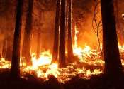
Northern forest fires could accelerate climate change

New research indicates that the computer-based models currently used to simulate how Earth's climate will change in the future underestimate the impact that forest fires and drying climate are having on the world's northernmost ...

Mapping North Carolina's ghost forests from 430 miles up

Emily Ury remembers the first time she saw them. She was heading east from Columbia, North Carolina, on the flat, low-lying stretch of U.S. Highway 64 toward the Outer Banks. Sticking out of the marsh on one side of the road ...

Landsat satellite data warns of harmful algal blooms

Come summer, Utahns will flock to the state's lakes and reservoirs to boat, swim and picnic along the shore. And every week, if not every day, scientists like Kate Fickas of Utah State University in Logan will use satellite ...

page 22 from 40