NASA's Terra satellite analyzes Caribbean's Tropical Depression 14
NASA's Terra satellite gathered infrared data on Tropical Depression 14 as it moves through the Caribbean Sea. Infrared data was used to find the location of the strongest storms.

NASA's Terra satellite gathered infrared data on Tropical Depression 14 as it moves through the Caribbean Sea. Infrared data was used to find the location of the strongest storms.
Environment
Aug 21, 2020
0
5

Five years after its destruction, the ancient Temple of Bel in Palmyra, Syria has been digitally reconstructed by the UC San Diego Library's Digital Media Lab using cutting-edge 3-D methods and artificial intelligence applications.
Archaeology
Aug 21, 2020
0
188

Tropical Storm Josephine weakened on Aug. 16 in the North Atlantic Ocean and satellite imagery showed the storm had become elongated and stretched out into a trough of low pressure a couple of hundred miles north of Puerto ...
Environment
Aug 17, 2020
0
5

After Tropical Depression 07W formed close to the western Philippines, it moved away and strengthened into a tropical storm in the South China Sea. NASA's Terra satellite provided a look at the strength of the storms that ...
Environment
Aug 10, 2020
0
5

Tropical Storm Jangmi was exiting the East China Sea and moving toward the Sea of Japan when NASA's Aqua satellite measured the strength of the system.
Environment
Aug 10, 2020
0
9

After Tropical Depression 09E formed near the coast of southwestern Mexico, infrared data from NASA's Aqua satellite helped confirm its transition to a tropical storm.
Environment
Aug 10, 2020
0
11
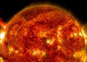
Solar flares—violent explosions on the surface of the sun—can send blasts of radiation hurtling toward Earth. While the planet's magnetic field protects humans on the surface, powerful solar flares can disable satellites, ...
Space Exploration
Jul 31, 2020
135
326

A radical new method of imaging that harnesses artificial intelligence to turn time into visions of 3-D space could help cars, mobile devices and health monitors develop 360-degree awareness.
Optics & Photonics
Jul 30, 2020
0
1117

Former Hurricane Douglas has encountered strong wind shear after passing the Hawaiian Islands and has now weakened to a tropical storm. NASA's Terra satellite provided infrared data to find that the strongest storms were ...
Environment
Jul 28, 2020
0
9

NASA's Aqua satellite used infrared light to identify the strongest storms and coldest cloud top temperatures in Tropical Depression 8, spinning in the Gulf of Mexico.
Environment
Jul 23, 2020
0
3