Surveying The Future
A new low cost system that illustrates immediately a 3D model of a room has been developed by an Israeli company. The system facilitates the performing of highly accurate computerized measurements inside buildings. It allows a single operator to measure a room and create a CAD (Computer-aided design) model in real time which can then be used to plan the further development of the interior structure. Relying on ultra sound and RF transmission between its base station and a portable unit, the new system eliminates limitations such as line of sight and the need for "open skies" that exist in current surveying equipment, while still keeping the price of the overall system well below that of existing equipment.
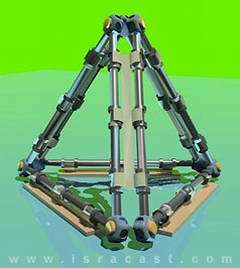
Image above: Three QS Bases assembled in a triangle pyramid structure
Surveying is an age old profession. Some of the first surveyors came from ancient Egypt where they used various tools including knotted ropes to measure distances for construction work and other applications. More sophisticated measuring instruments have been devised over the years and in the last few decades two such important instruments created a revolution in the world of geodesy. The laser range finder and the Global Positioning System (GPS) helped to dramatically improve the accuracy of measurements, ease of use and the overall cost of surveying operations.
Despite these important advances even the most up-to-date surveying systems like the Real-Time-GPS (RTK-GPS) and the "Total Station" (TS) still have their limitations. RTK-GPS still requires "open sky" in order to receive the satellite signal and thus is limited when performing measurements indoors, in high density built areas, afforested areas, etc.. TS is limited by line of site, and lighting conditions in the area. All existing systems require the use of a "measuring rod" and sustaining it in a vertical position. The existing systems are also expensive, starting at tens of thousands of dollars per unit, and are used mostly by professional surveyors.
To overcome these limitations a team of Israeli professional surveyors and engineers set out to create a revolutionary new device called QuickSurveyor. The new system is composed of two units, a base station and a lightweight mobile unit called Rover. The Base station is essentially a 50cm high metallic pyramid with nine tiny RF and ultra sound transmitters / receivers built into it. The Rover is a portable unit shaped like a telescopic rod 1meter in length, which can extend up to 3m to help measure high ceilings, and other hard to reach places. The rod includes 3 sensors triangular in shape and can be aided by laser distance meter to increase its range. The Rover unit can also include a handheld computer which shows the measurements' progress in real time. Alternatively, the Rover can transmit the data to a laptop placed nearby.

The measuring process is much simpler than that of existing systems. The surveyor places the base unit in the center of the area being measured and starts walking with the Rover unit in his hand. By touching a wall, ceiling or window with the three sensors at the end of the Rover, the surveyor establishes a coordinates for the system which immediately turns it into part of a 3D model of the room.

EZ2CAD is currently looking for investors for the first stage of R&D as well as the later stage of creating a commercial product. The company plans to market its innovative system in about two years.
by Iddo Genuth - IsraCast
The original story can be found at http://www.isracast.com/tech_news/010705_tech.htm
For any comments about this story, please contact the writer of the original article
© 2005 IsraCast. Published with permission of Iddo Genuth


