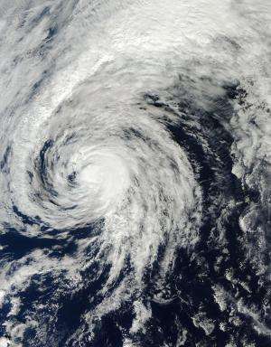
Satellite movie shows Tropical Storm Ana headed to British Columbia, Canada

An animation of imagery from NOAA's GOES-West satellite taken over the period of Oct.19 to 26 shows the movement, intensification, weakening and movement toward British Columbia, Canada. On Oct. 27, wind warnings were posted along some coastal sections of British Columbia.
During the week of Oct. 19 Ana moved west of the Hawaiian Islands and into the open waters of the Central Pacific Ocean, strengthening into a hurricane and weakening back to a tropical storm. A 20 second video of the storm's movement was created by NASA/NOAA's GOES Project at NASA's Goddard Space Flight Center in Greenbelt, Maryland.
On Oct. 26, NOAA's Central Pacific Hurricane Center issued the final bulletin on Ana. At 1500 UTC (11 a.m. EDT), it was a tropical storm with maximum sustained winds near 40 knots. Ana was located near 42.2 north latitude and 147.9 west longitude, about 1,555 miles north-northeast of Honolulu, Hawaii. It was moving to the east-northeast at 40 knots (46 mph/74 kph). Ana has transitioned into an extra-tropical storm, meaning that its core changed from a warm system to a cold core system, like a typical mid-latitude weather system.
At 5:05 a.m. PDT on Monday, October 27, Environment Canada's Meteorological Service posted a Wind warning in effect for British Columbia's Central coast, Vancouver Island, Haida Gwaii, North Vancouver Island, and the Sunshine Coast. The warning noted strong winds may cause damage are expected or occurring. In addition, there will likely be heavy rainfall associated with the system and rainfall amounts of 50 to 75 mm (~2 to 3 inches) are possible for tonight into Tuesday.
The EC noted that the remains of Tropical Storm Ana will move towards the British Columbia Coast later today (Oct. 27) and tonight. Southeast winds are forecast to increase to 90 kph (56 mph) over exposed coastal sections by this evening. Winds will then gradually ease through Tuesday morning.
Environment Canada meteorologists will update alerts as required. For updates, visit: http://weather.gc.ca.
Provided by NASA's Goddard Space Flight Center


