This article has been reviewed according to Science X's editorial process and policies. Editors have highlighted the following attributes while ensuring the content's credibility:
fact-checked
peer-reviewed publication
trusted source
proofread
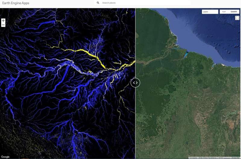
New study of river channel belts results in a valuable online map

A new study authored by Björn Nyberg and colleagues offers the world's first comprehensive classification of river channel belts at a 30-meter resolution.
River channel belts are wide corridors created by the movement of a river. The interactive map developed by Nyberg and colleagues shows the global distribution of river channel belt extents. The channel belt extents include not only the active river channels, but also the overbank deposits created by rivers' gradual movement over time.
"The new global map developed in this study offers an unprecedented level of detail that can vastly improve our understanding of the river channel belt and its ecological significance," says Björn Nyberg.
The study appears in Nature Communications.
An interactive and extraordinarily detailed map
"The map can help us understand river channel belts better, predict how they will change, and enable us to assess the potential impact of flooding in the future," says Nyberg. The map could also be a highly useful tool when attempting to predict climate change, he claims: "River channel belts are unique and vital ecosystems. They store and release carbon. Understanding these ecosystems better can help us generate more accurate climate change predictions."
Nyberg and the rest of the research team employed novel methods when developing the map.
"We utilized a state-of-the-art machine learning algorithm that identifies the intricate patterns of river systems. It would have been impossible to create a detailed map like this using traditional remote sensing techniques."
A valuable tool
Nyberg believes the study could have broad implications.
"The comprehensive classification of river channel belts provided by this research can serve as a valuable tool for sustainable development and management of river systems."
He hopes the maps and datasets generated in the study will inspire further research focused on enhancing flood risk management, ecosystem conservation and water resource management, and he anticipates that the methods developed in the study will serve as a model for creating other high-resolution global landform maps.
"More high-resolution landform maps could unlock new opportunities for numerous fields across academia, government, industry, and non-profit organizations."
"The study is the result of a collaborative effort involving Prof. Rob Gawthorpe at the University of Bergen, along with Gijs Henstra, Rodmar Ravnås, and Juha Ahokas from AkerBP ASA who brought extensive expertise in sedimentology and geomorphology," says Nyberg.
"Their expertise was essential in the development of a machine learning algorithm capable of characterizing all the elements that define river systems."
He hopes their study will reach researchers from many different disciplines.
"The audience of Nature Communications includes hydrologists, biologists, geologists, ecologists, and computer scientists, which makes this journal an ideal place to publish given the wide implications of the study."
More information: Björn Nyberg et al, Global scale analysis on the extent of river channel belts, Nature Communications (2023). DOI: 10.1038/s41467-023-37852-8
Journal information: Nature Communications
Provided by University of Bergen


