This article has been reviewed according to Science X's editorial process and policies. Editors have highlighted the following attributes while ensuring the content's credibility:
fact-checked
peer-reviewed publication
trusted source
proofread
Precipitation variations indicate the northern boundary and climate regimes of the Asian summer monsoon

Precipitation patterns and their variations over the Tibetan Plateau (TP) are mainly dominated by the Asian summer monsoon (ASM), westerlies, and their interactions. The exact extent of the ASM's influence, however, remains undetermined. The northern boundary of the ASM denotes the northernmost position, with its leading edge advancing from south to north after its outbreak.
In addition, the unique topography and location of the Tibetan Plateau (TP) enable the ASM to penetrate deeply into the mid-latitudes. Thus, the northern boundary of the ASM could be considered as a boundary between the monsoon and the westerlies. Although some studies on the northern boundary of the EASM have mentioned the northern monsoon boundary of the TP region, these studies do not fully address the rationality of the boundary position in the TP.
In addition, the strength and extent of the ASM during different periods will also change under the external forcing and internal variability. Therefore, a precise and reliable northern boundary index is urgently needed to examine relative changes in the ASM position and the extent of and variation in the circulation system during different periods over the TP.
To overcome these issues, the northern boundary of the ASM over the TP is defined in this paper to precisely identify its position and variability. The ASM delivers substantial moisture to the TP. The ASM's subsystems, the SASM and the EASM, primarily affect the southern and eastern areas of the TP, respectively, forming a rainfall pattern that decreases from southeast to northwest during the rainy season.
Referencing the climatological northern boundary index of the East Asian summer monsoon, this study is an attempt to evaluate its accuracy in reflecting the boundary position by considering natural geographical features such as climate and ecology and the movement of the ASM over the TP. Finally, the present study further analyzes the annual spatial characteristics of the northern boundary and demarcates the westerlies and monsoon domains over the TP.

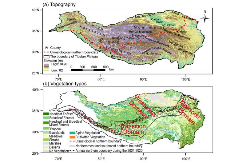
The results show that the CNBI can reasonably illustrate the northern boundary of the ASM over the TP. Geographically, the climatology of the northern boundary of the ASM is distributed along the eastern Qilian Mountains-Tanggula Mountains-Qiangtang Plateau-Gangdise Mountains-Western Himalayas.
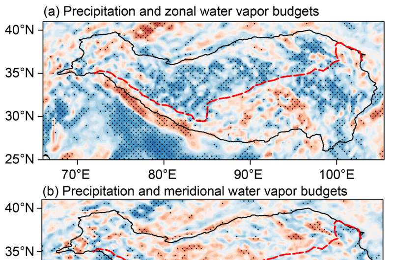
This boundary roughly coincides with the boundary of the endorheic and exorheic basins of the TP. Climatically, the climatological northern boundary of the ASM is characterized by the convergence of westerly and southerly winds in the low troposphere and a distinct boundary between changes in the net zonal and meridional (westerlies and monsoon) water vapor budget and changes in precipitation, reflecting the interface between dry and wet regions during the rainy season over the TP.
Ecologically, the interannual fluctuation range of the climatological northern boundary index corresponds well to the distribution of grasslands and meadows over the TP.
Based on the interannual variation range of the northern boundary of the ASM, we define the region north of the southernmost boundary of the interannual variability of the northern boundary of the ASM as the westerlies domain, the region south of the northernmost boundary of the interannual variability of the northern boundary of the ASM as the monsoon domain, and the area between the southernmost and northernmost boundary as the westerlies-monsoon transition domain over the TP.
This study could serve as a foundation for further investigation into the interactions between westerlies and monsoon, variations in precipitation patterns and hydrological-ecological systems over the TP.
The findings are published in the journal Science China Earth Sciences.
More information: Lingxin Huang et al, The northern boundary of the Asian summer monsoon and division of westerlies and monsoon regimes over the Tibetan Plateau in present-day, Science China Earth Sciences (2023). DOI: 10.1007/s11430-022-1086-1
Journal information: Science China Earth Sciences
Provided by Science China Press


