This article has been reviewed according to Science X's editorial process and policies. Editors have highlighted the following attributes while ensuring the content's credibility:
fact-checked
peer-reviewed publication
trusted source
proofread
Glacial rocks reveal the geology hidden beneath the East Antarctica Ice Sheet

A trove of ancient rocks collected from glacial moraines has literally revealed the deep story of one of the most underexplored environments on the planet—the rocks and mountain belts hidden beneath the East Antarctica Ice Sheet. Before this study, scientists had only the vaguest idea of when, how and why the mountains and landscapes now buried under the world's largest ice sheet had formed.
"These mountains and landscapes have been buried under miles of ice for the past 14 million years," says Paul Fitzgerald, professor of Earth and environmental sciences at the College of Arts and Sciences. "They are much more remote than Mount Everest or the deepest part of the ocean."
Now, some of that inaccessible region's tectonic mysteries have been solved. In a study recently published in Nature Communications, first author Fitzgerald and second author John Goodge, a professor emeritus of geological sciences at the University of Minnesota Duluth, used innovative rock sampling and radiometric dating on those rocks to reveal the history of central East Antarctica over the past half-billion years.
Mysterious mountains
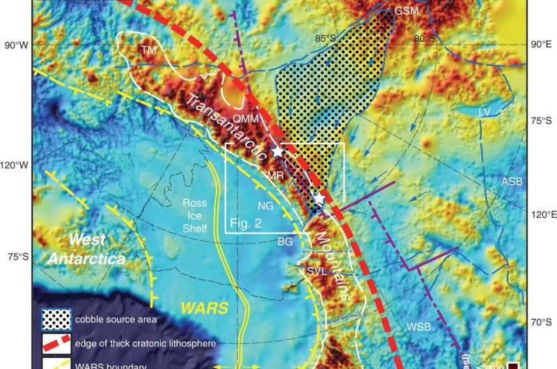
The researchers selected granite boulders ranging in age from 1 to 2 billion years old, knowing that rocks of this age do not occur anywhere else in Antarctica and must therefore come from well under the ice sheet, perhaps from the large and mysterious Gamburtsev Subglacial Mountains. This is because as mountains erode, glaciers—slow-moving rivers of ice—transport the boulders to fields of deposited rock and sediment, called glacial moraines, near the edge of the continent.
Scientists have long puzzled over the Gamburtsev Subglacial Mountains purely because they are completely buried under the ice, and no one knows what rock types make up the range. Recent sub-ice images of the range suggest a non-volcanic origin, but if not volcanism, then what tectonic forces were responsible for its formation? Knowing when the mountains formed means researchers can start to solve this puzzle.
But how do you determine when a mountain belt formed, let alone one that is completely buried under the ice? By determining the low-temperature cooling history of the rocks. And that's where complementary expertise comes into play.
Fitzgerald, a New Zealand native, and Goodge, an American, have been good friends since meeting as graduate students in the Transantarctic Mountains in 1986. But they had never worked together. Now they had a chance to do just that. Goodge had collected the boulders and Fitzgerald had the expertise with thermochronology. Both have been working on Antarctic geology for decades.
When mountains are formed, they are uplifted and form high topography. Due to erosion, rocks are then exhumed toward the surface. As rocks are exhumed, they cool. Determining when and how fast rocks cool helps narrow down when in geologic time the mountains formed. Geologists use thermochronology—analyzing the time-temperature history of rocks through radiometric dating—to understand the cooling history. The relatively large size of the boulders allowed researchers to analyze the boulders using a variety of radiometric methods.
The findings
The results showed that the interior of East Antarctica had experienced three major periods of rapid cooling which are due to major tectonic events. First, the supercontinent Gondwana formed due to continent-continent collision about 500 million years ago. Second, the Gondwana supercontinent started to break up about 180 million years ago. Finally, a high-elevation plateau started to collapse about 100 million years ago, associated with formation of a rift-system between East and West Antarctica. All in all, these conclusions make good geologic sense.
These are still very early days in understanding the geologic puzzles that are concealed by the vast mass of the East Antarctic Ice Sheet. What stands out for Fitzgerald, though, is the excitement of discovery. "We were sampling a place that we knew very little about. For us, this was like having rocks to study from the moon or Mars," he says.
More information: Paul G. Fitzgerald et al, Exhumation and tectonic history of inaccessible subglacial interior East Antarctica from thermochronology on glacial erratics, Nature Communications (2022). DOI: 10.1038/s41467-022-33791-y
Journal information: Nature Communications
Provided by Syracuse University


