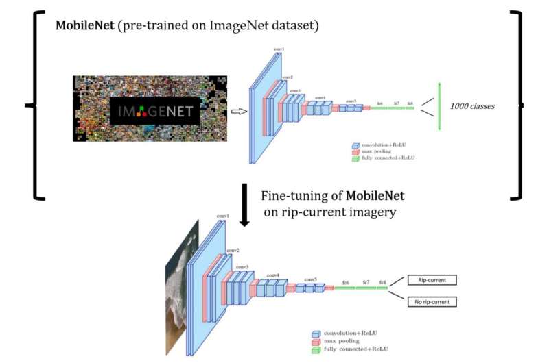
The general application of applying transfer learning. First, a CNN (MobileNet) is trained on an extremely large dataset. Next, the CNN is fine-tuned on a smaller dataset. The architecture of a CNN consists of convolutional layers (blue), which have a series of convolutional kernels that extract features from the images. The maximum pooling (red) layers help reduce the dimensionality of the data and discard redundant features. Finally, the fully connected layers (green) further reduce the dimensionality of the data into a compressed latent representation. The final layer makes a prediction into two classes: rip current or no rip current. Credit: Remote Sensing (2022). DOI: 10.3390/rs14236048
Beachgoers could be safer thanks to a new technology with the potential to give real-time updates of rip currents.
Rip currents are narrow, fast-moving segments of water that travel away from the shore. They can reach speeds of 2.5 meters per second, which is quicker than the fastest Olympic swimmer.
NIWA and Surf Life Saving New Zealand (SLSNZ) have developed a state-of-the-art rip current identification tool using artificial intelligence (AI) and deep learning. The tool showed around 90% accuracy detecting rip currents in videos and images in trials. The work is published in the journal Remote Sensing.
NIWA coastal scientists Dr. Christo Rautenbach and Neelesh Rampal say the technology has been tested on a large variety of images from different coastal settings and they hope will ultimately be used by beachgoers to alert them of rip currents.
"We hope that by using cameras and drones at beaches, the tool will be able to scan video footage and notify people of the presence of rip currents. Even knowledgeable surf lifeguards can struggle identifying rips, depending on the beach and environmental conditions. As well as this, some beaches are remote or really large, so surf lifeguards can use all the extra help they can get," said Dr. Rautenbach.
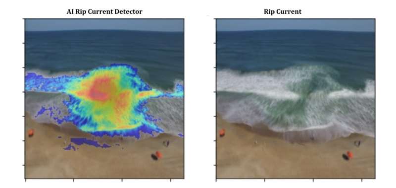
The "warmer" colors are where the AI is focusing—it gives a probability score that shows, with various confidence, that a potentially deadly rip current is in that area. Credit: NIWA
The technology was developed by feeding millions of coastal aerial images into the AI model, along with artificial rain and fog data, to teach it to identify where rips occur in real-time, regardless of weather conditions and camera angle.
Adam Wooler, Special Projects Manager at SLSNZ, says once operationalized the technology will be invaluable for people while they're out enjoying our beautiful coastline.
"This is only the beginning of our research together and our goal is to build even more effective, accurate and reliable safety tools for New Zealand beaches. Rip currents can sweep even the strongest swimmers out to sea—we had 90 people sadly drown in New Zealand last year, 25 of them on beaches, so we're hoping that this technology helps to significantly reduce that number," said Wooler.
Rip currents are reported as the most hazardous safety risk to beachgoers around the world. An Australian study published in 2013 revealed that they have killed more people on Australian territory than bushfires, floods, cyclones, and shark attacks combined.
More information: Neelesh Rampal et al, Interpretable Deep Learning Applied to Rip Current Detection and Localization, Remote Sensing (2022). DOI: 10.3390/rs14236048
Provided by NIWA


