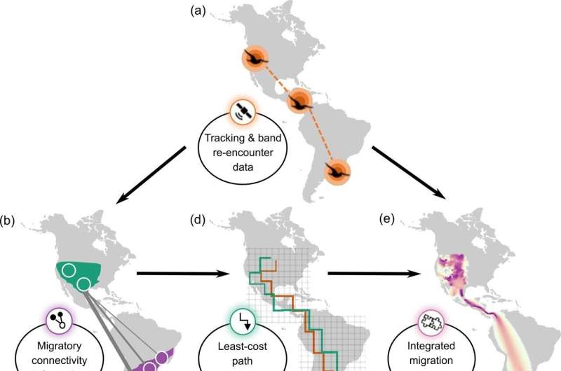
Figure demonstrating the integration of different data types to visualize the fall migration of the Swainson's Hawk. Credit: (Meehan et al. 2022)
More than forty scientists from the National Audubon Society and other leading bird and wildlife research and conservation groups published a new study modeling a novel approach to mapping seasonal migration pathways for birds. The study, published recently in Ecological Applications, combines some of the best-available forms of migration data for 12 species of migratory birds that represented different families, migratory strategies, breeding ranges, and available dataset sizes. This new method is a powerful advancement for migratory bird conservation at a time when many species are dramatically declining.
"Migratory birds complete some of the most impressive journeys on Earth, and this new method of mapping their migrations gives us a clearer picture of the places these birds travel," said Dr. Tim Meehan, quantitative ecologist for the National Audubon Society and primary author of the study.
The migration data used in this study can be categorized broadly into three types: occurrence and abundance models, represented by eBird Status products from the Cornell Lab of Ornithology; band re-encounter data, provided by the USGS Bird Banding Laboratory; and tracking datasets provided by researchers from across the globe and made available on Movebank. The researchers integrated these types of migratory data for 12 focal species, leveraging the strengths of each, to create a comprehensive—and accurate—map of migratory bird movements. The models give researchers a unique picture of avian migration, especially for species with over-water migrations or migrations that take place across isolated geographies.
"Birds tell us about the health of our environment, and better mapping of their migration pathways shows us where we should focus conservation efforts," said Dr. Jill Deppe, senior director of Audubon's Migratory Bird Initiative and a co-author of the study. "These new maps will help communities all across the hemisphere protect migratory birds and the places they need."
For many species of migratory birds, the complete annual cycle remains relatively unknown or poorly understood. The three data types describe the annual cycle in different ways; banding data and tracking provide detailed information on how individual birds move across the hemisphere often enabling connections between breeding and wintering populations, but they provide limited information about the movement of the entire population.
The eBird Status products use information collected by community scientists to provide information about the distribution of the entire population throughout the year. By combining these two types of data, the researchers were able to generate maps that describes the pathways by which migratory birds move across the hemisphere. Migratory birds are also facing steep declines, with an estimated 2.5 billion individuals lost between 1970 and 2019. This unique information about migratory pathways will allow conservationists across the hemisphere to more effectively protect and restore the habitats that these birds depend on throughout their full annual cycle.
More types of migration data can allow for even further development of this integration, filling in knowledge gaps for species across the hemisphere.
"The more data we have and the better the tracking technology becomes, the clearer these migration pathways can get," said Dr. Sarah Saunders, quantitative ecologist and co-author of the study. "It's exciting to be able to work with researchers from across the globe to put these pieces together and give us the best chance at protecting migratory birds."
More information: Timothy D. Meehan et al, Integrating data types to estimate spatial patterns of avian migration across the Western Hemisphere, Ecological Applications (2022). DOI: 10.1002/eap.2679
Journal information: Ecological Applications
Provided by National Audubon Society


