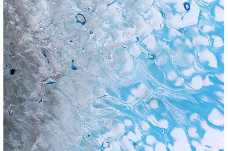
Meltwater and surface lakes on the Greenland ice sheet. Credit: contains modified Copernicus Sentinel data (2021), processed by ESA
For the first time ever recorded, in the late summer of 2021, rain fell on the high central region of the Greenland ice sheet. This extraordinary event was followed by the surface snow and ice melting rapidly. Researchers now understand exactly what went on in those fateful summer days and what we can learn from it.
The never-before-seen rainfall, on 14 August 2021, made headlines around the world. The upper-most parts of Greenland's enormous ice cap used to be too cold for anything other than snow to fall, but not anymore.
What caused this extreme rainfall and how did it affect the ice?
Researchers from the Department of Glaciology and Climate at the Geological Survey of Denmark and Greenland (GEUS) in collaboration with colleagues from France and Switzerland have scrutinized these questions and come up with the answers.
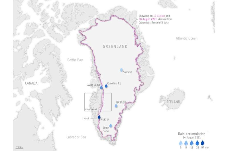
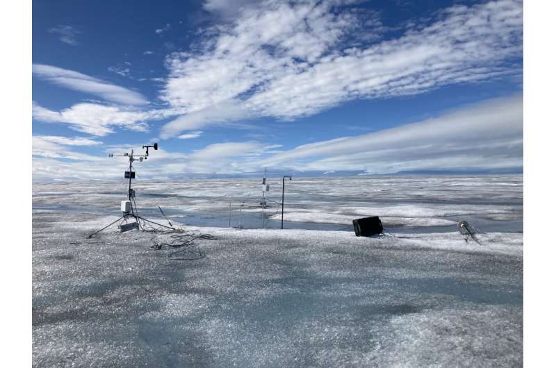
It didn't only rain at Summit Camp—rain was measured by new automatic weather stations placed across the ice sheet by GEUS' ice-sheet monitoring projects PROMICE and GC-Net.
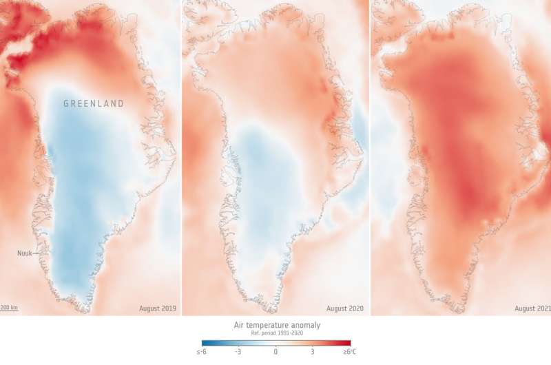
Studying detailed data from these stations alongside measurements of surface reflectivity, or albedo, from the Copernicus Sentinel-3 satellite mission and information on atmospheric circulation patterns, the researchers discovered that the rain had been preceded by a heatwave at a time of year when seasonal melting is usually slowing down.
Greenland air temperature for August 2019, 2020, 2021, compared to the 1991–2020 August average. Credit: Copernicus Climate Change Service/ECMWF/ESA (data ERA5)
It wasn't the rain
"It turns out that the rain itself wasn't the most important factor," says Prof. Jason Box from GEUS and lead author of the paper reporting their results, which has been accepted for publication in Geophysical Research Letters.
"There is an irony. It's not really the rain that did the damage to the snow and ice, it's the darkening effect of the meltwater and how the heat from the event erased snow that had overlaid darker ice across the lower third of the ice sheet.
"Unusually warm atmospheric rivers swept along Greenland in the late summer months, bringing potent melt conditions when the melt season was drawing to a close."
In fact, this sudden increase of surface ice melt on Greenland could have happened without any rain ever touching the ground.
The main culprit was the heat itself, melting and completely removing the surface snow, thereby changing the surface albedo, Greek for "whiteness," so that Greenland snow and ice absorbed more of the Sun's rays.
Greenland snowline retreat and rainfall. Credit: contains modified Copernicus Sentinel data (2021) and GEUS weather station data, processed by ESA
The researchers found that, between 19 and 20 August 2021, this melt caused the altitude of the ice sheet's snowline near Kangerlussuaq to retreat in elevation by a whopping 788 meters, the snowline retreated, exposing a wide area of dark bare ice.
Under normal circumstances, snow would cover and insulate this ice, but the snow melted suddenly and exposed the ice to heat, causing even more melting.
Since 2017, Prof. Box and colleagues have been consistently monitoring these melt dynamics with data from the Copernicus Sentinel-3 mission as part of their research supported by ESA's Earth Observation Science for Society program.
They found that more bare ice had been exposed on the one day of 19–20 August than any other day since their research began.
Weather station high on the Greenland ice sheet. Credit: GEUS
So what does this mean?
The authors conclude that the heatwave causing the rain event serves as an excellent example of "melt-albedo feedback that amplifies the melt impact of the initial melt perturbation."
Besides the obvious and concerns of making the ice sheet melt faster while this was happening, studying the event using detailed measurements from the network of automatic weather stations on the ice set up by GEUS coupled with measurements from the Copernicus Sentinel-3 satellites in space helps understand the exact processes and dynamics of how ice melts.
For the first time ever recorded, in the late summer of 2021, rain fell on the high central area of the Greenland ice sheet. This extraordinary event was preceded by a heatwave and followed by the surface snow and ice rapidly melting. The animation is a series of five images captured by the Copernicus Sentinel-2 mission and shows how the surface of the ice sheet changed between on 1, 3 5, 20 and 23 August 2021. The melt, which also created lakes on the surface of the ice, is clear to see. Researchers, supported by ESA’s Science for Society programme, discovered that it wasn’t actually the rain that caused the melt, it was unusually warm ‘atmospheric rivers’ that swept along Greenland, bringing potent melt conditions when the melt season would normally be drawing to a close. Credit: contains modified Copernicus Sentinel data (2021), processed by ESA
Even though the rainfall was a shock and a milestone in climate history, researchers knew it was bound to happen sooner or later, given the rising temperatures of the Arctic.
Therefore, Prof. Box and the co-authors encourage research to look further into the workings behind atmospheric rivers and not just rainfall.
They conclude that understanding the frequency of heatwaves, appears to be a more significant research target than the liquid precipitation that heatwaves may or may not produce.
Journal information: Geophysical Research Letters
Provided by European Space Agency


