Mapping the best places to plant trees

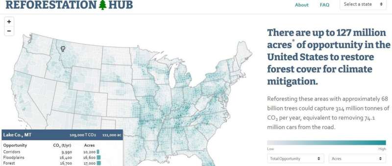
Reforestation could help to combat climate change, but whether and where to plant trees is a complex choice with many conflicting factors. To combat this problem, researchers reporting in the journal One Earth on December 18 have created the Reforestation Hub, an interactive map of reforestation opportunity in the United States. The tool will help foresters, legislators, and natural resource agency staff weigh the options while developing strategies to restore lost forests.
"Often the information we need to make informed decisions about where to deploy reforestation already exists, it's just scattered across a lot of different locations," says author Susan Cook-Patton, a Senior Forest Restoration Scientist at the Nature Conservancy. "Not everybody has the computer science experience to delve into the raw data, so we tried to bring this information together to develop a menu of options for reforestation, allowing people to choose what they would like to see in their community, state, or nation."
The culmination of these efforts is the Reforestation Hub, a web-based interactive map that color-codes individual counties by reforestation opportunity or level of potential for successful reforestation. And the results show that there is a great deal of reforestation opportunity in the United States.
"There are up to 51.6 million hectares (about 200,000 square miles) of opportunity to restore forest across the United States after excluding productive cropland and other places where trees are infeasible," she says. "Those additional forested areas could absorb the emissions equivalent to all the personal vehicles in California, Texas, and New York combined."
In addition to quantifying the amount of land that could yield viable forests, the Hub also identifies trends in how this opportunity is distributed throughout the country.
"While there's no single best place to restore forest cover, we did find a particularly high density of opportunity in the Southeastern United States," says Cook-Patton. "This is a region where carbon accumulation rates are high, costs are low, and there is a lot of opportunity to achieve multiple benefits like creating habitats for biodiversity, improving water quality, and climate mitigation."
The map also quantifies the acreage of 10 individual opportunity classes—or categories based on land ownership and quality. Some of these include pastures, post-burn lands, and floodplains. "The choice to plant trees really depends on what people want out of the landscape, whether it's controlling flood waters, improving urban environments, or recovering forests after a fire," she says.
The researchers hope to create similar maps for other countries, an important next step for combating the global problem of climate change.
"We have about a decade to get climate change in check," Cook-Patton says, "and I am excited about the potential for this study to help accelerate decisions to invest in reforestation as a climate solution."
More information: Susan C. Cook-Patton et al, Lower cost and more feasible options to restore forest cover in the contiguous United States for climate mitigation, One Earth (2020). DOI: 10.1016/j.oneear.2020.11.013
Journal information: One Earth
Provided by Cell Press


