NASA tracking Tropical Storm Laura near Cuba

As Tropical Storm Laura continues to move through the Caribbean Sea NASA satellites are providing forecasters with visible, infrared and microwave data. Laura continued to move through the Caribbean Sea on a march toward the Gulf of Mexico.
Warnings and watches on August 24, 2020
NOAA's National Hurricane Center (NHC) issued many warnings and watches on Sunday, Aug. 24. A Tropical Storm Warning is in effect for Little Cayman and Cayman Brac; the Cuban provinces of Camaguey, Las Tunas, Ciego De Avila, Sancti Spiritus, Villa Clara, Cienfuegos, Matanzas, Mayabeque, La Habana, Artemisa, Pinar del Rio, and the Isle of Youth and for the Florida Keys from Craig Key to Key West and the Dry Tortugas.
Hurricane and Storm Surge Watches will likely be required for portions of the U.S. northwest Gulf coast area by evening on Aug. 24.
NASA's infrared data reveals heavy rainmakers
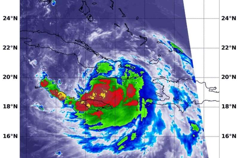
Very powerful storms with heavy rainmaking capability reach high into the atmosphere and those have very cold cloud top temperatures. Infrared imagery from NASA's Terra satellite measured those temperatures and found powerful storms in Tropical Storm Laura drenching parts of Jamaica.
Tropical cyclones are made of up hundreds of thunderstorms, and infrared data can show where the strongest storms are located. That is because infrared data provides temperature information, and the strongest thunderstorms that reach highest into the atmosphere have the coldest cloud top temperatures.
On Aug. 23 at 11:45 p.m. EDT (Aug. 24 at 0345 UTC),the Moderate Resolution Imaging Spectroradiometer or MODIS instrument that flies aboard NASA's Terra satellite used infrared light to analyze the strength of storms within Laura. The most powerful thunderstorms were in a small area around Laura's center where cloud top temperatures were as cold as or colder than minus 80 degrees Fahrenheit (minus 62.2 Celsius), just north of Jamaica. Strong storms with cloud top temperatures as cold as minus 70 degrees Fahrenheit (minus 56.6. degrees Celsius) surrounded those areas and were affecting Jamaica. They were also dropping large amounts of rain.
Forecasters at NOAA's NHC use NASA's infrared data in their forecast. Laura is expected to produce rainfall total accumulations through today of 4 to 6 inches, with maximum amounts of 10 inches in Jamaica, Cuba and the Cayman Islands. Across the Greater Antilles this heavy rainfall could lead to life-threatening flash and urban flooding, and the potential for mudslides.

NASA's visible look at Laura
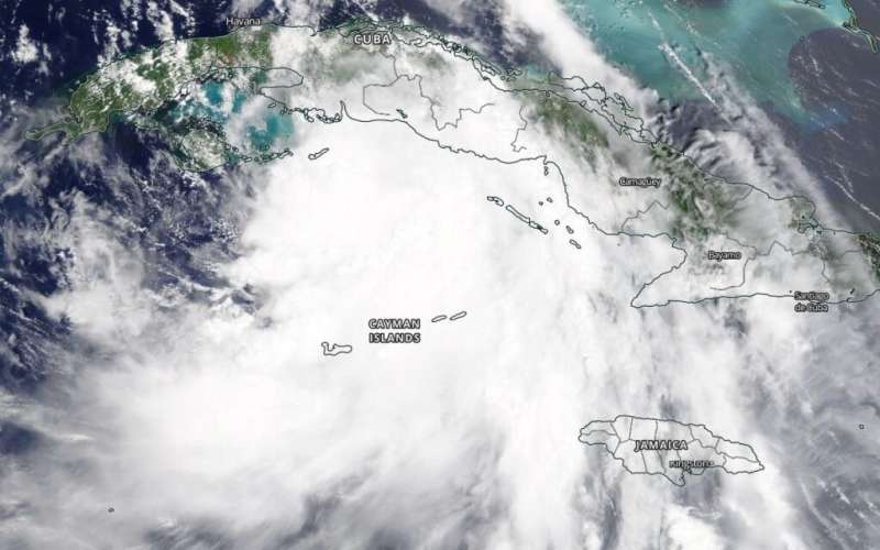
On Aug. 24 at 1:30 p.m. EDT, the MODIS instrument aboard NASA's Terra satellite provided a visible image of Tropical Storm Laura in the Caribbean Sea. At that time, the center of circulation appeared to be south of Cuba and north of the Cayman Islands. Laura had moved past Jamaica.
Forecasters at the National Hurricane Center looking at visible imagery noted, "Laura's satellite presentation has degraded somewhat since yesterday, however, there has been a recent increase in convection near the center, and a large band over the southern periphery of the circulation. It appears that the combination of land interaction, moderate northerly [vertical wind] shear, and some dry air has caused the change in structure."
Laura's status on July 26, 2020
At 11 a.m. EDT (1500 UTC), the center of Tropical Storm Laura was located near latitude 21.2 degrees north and longitude 80.6 degrees west. That is about 65 miles (105 km) east-southeast of Cayo Largo, Cuba.
Laura was moving toward the west-northwest near 20 mph (31 kph), and this general motion with some decrease in forward speed is expected over the next day or so. NOAA and Air Force reconnaissance aircraft indicate that the maximum sustained winds are near 60 mph (95 kph) with higher gusts. Little change in strength is forecast today, but strengthening is expected when the storm moves over the Gulf of Mexico, and Laura is forecast to become a hurricane on Tuesday, with additional strengthening forecast on Wednesday. The estimated minimum central pressure based on reconnaissance aircraft data is 1002 millibars.
Laura's forecast from NHC
NHC Senior Hurricane Forecaster Dan Brown noted in the 11 a.m. EDT discussion, "Laura is forecast to pass over the very warm water of the extreme northwestern Caribbean Sea just south of the coast of Cuba today, and some modest strengthening is possible before the center moves over the western portion of Cuba this evening. Laura is then forecast to emerge over the southeastern Gulf of Mexico overnight where a combination of warm sea surface temperatures and a favorable upper-level environment are expected to allow for steady strengthening."
Provided by NASA's Goddard Space Flight Center


