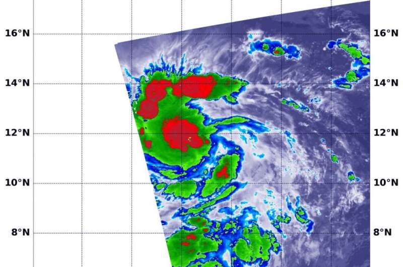
NASA infrared confirms Douglas still a tropical storm

Infrared data from NASA's Terra satellite showed that dry air around Tropical Storm Douglas has been inhibiting it from strengthening into a hurricane.
On July 22 at 2:15 a.m. EDT (0615 UTC), the Moderate Resolution Imaging Spectroradiometer or MODIS instrument aboard NASA's Terra satellite gathered temperature information about Tropical Storm Douglas' cloud tops. Infrared data provides temperature information, and the strongest thunderstorms that reach high into the atmosphere have the coldest cloud top temperatures.
MODIS found powerful thunderstorms where temperatures were as cold as or colder than minus 70 degrees Fahrenheit (minus 56.6 Celsius) around the center and in a thick band of thunderstorms north of the center. Cloud top temperatures that cold indicate strong storms with the potential to generate heavy rainfall.
Forecasters noted that Douglas' overall appearance has changed little over the early morning hours on July 22. Douglas has not intensified to hurricane status because dry air is affecting the eastern portion of the cyclone's circulation and preventing thunderstorm development. A tropical cyclone consists of hundreds of thunderstorms.
At 5 a.m. EDT (0900 UTC) on July 22, the National Hurricane Center (NHC) noted the center of Tropical Storm Douglas was located near latitude 11.9 degrees north and longitude 128.0 degrees west. Douglas is centered about 1,875 miles (3,020 km) east-southeast of Hilo, Hawaii.
Douglas is moving toward the west near 15 mph (24 km/h). A turn toward the west-northwest along with an increase in forward speed is forecast to occur by late Wednesday. The west-northwestward motion is forecast to continue at least through Saturday. Maximum sustained winds are near 65 mph (100 km/h) with higher gusts. The estimated minimum central pressure is 998 millibars.
Strengthening is forecast during the next couple of days, and Douglas is expected to become a hurricane on Wednesday, July 23. NHC forecaster Andrew Latto noted in the morning discussion, "The system is forecast to remain in a favorable environment for intensification for the next day or so. Beyond 36 hours, the combination of cooler SSTs and dry air should cause Douglas to slowly weaken."
Tropical cyclones/hurricanes are the most powerful weather events on Earth. NASA's expertise in space and scientific exploration contributes to essential services provided to the American people by other federal agencies, such as hurricane weather forecasting.
Provided by NASA's Goddard Space Flight Center


