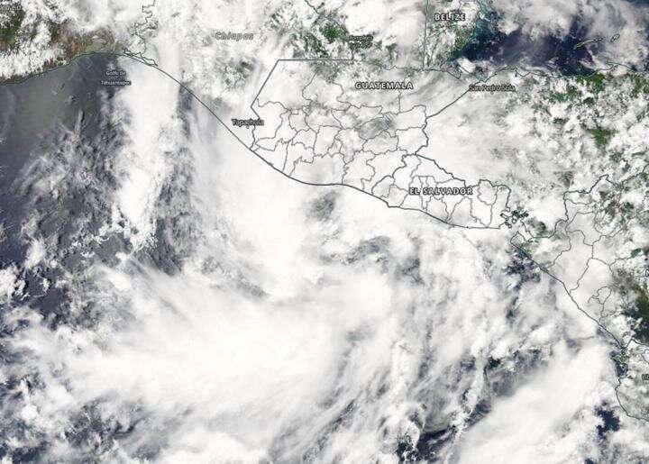
NASA catches short-lived Tropical Storm Amanda

Tropical Storm Amanda, the first of the Eastern Pacific Ocean hurricane season, formed on Sunday, May 31, along the coast of Guatemala and quickly moved inland. NASA's Aqua satellite provided a look at the storm as it was developing.
On May 31, 2020, the Moderate Resolution Imaging Spectroradiometer or MODIS instrument that flies aboard NASA's Aqua satellite provided a visible image of developing Tropical Storm Amanda in the eastern Pacific Ocean, just off the coast of Guatemala.
At 8 a.m. EDT on May 31, the National Hurricane Center noted that Eastern Pacific Tropical Storm Amanda had developed and had already moved inland over southeastern Guatemala. Once inland, it quickly weakened over the mountainous terrain of Guatemala.
By 5 p.m. EDT the same day, Amanda dissipated near latitude 16.0 degrees north and longitude 90.0 degrees west, about 100 miles (165 km) north-northeast of Guatemala City, Guatemala. The remnants were expected to generate heavy rainfall over portions of El Salvador, Guatemala, western Honduras, and southeastern Mexico over the next few days
The National Hurricane Center noted in its discussion on Sunday, May 31 at 5 p.m. EDT, "There have been reports of torrential rainfall from Amanda over portions of El Salvador and Guatemala during the past 12-24 hours. Although the system is no longer a tropical cyclone, the larger cyclonic gyre located over southeastern Mexico is likely to continue producing heavy rainfall over portions of Central America and southern Mexico during the next several days. These rains are likely to cause life-threatening flash floods and mudslides."
Amanda quickly weakened to a remnant low pressure area and tracked north toward Mexico's Yucatan Peninsula.
On Monday, June 1, the National Hurricane Center noted that Amanda might be reborn as an Atlantic Ocean basin tropical cyclone. "A large area of disturbed weather, associated with the remnants of eastern Pacific Tropical Storm Amanda, is located over the Yucatan peninsula of Mexico. This disturbance is forecast to move northwestward over the southeastern portion of the Bay of Campeche later today or tonight where environmental conditions are expected to be conducive to support development, and a new tropical depression is likely to form within the next day or so."
NASA's Aqua satellite is one in a fleet of NASA satellites that provide data for hurricane research.
Tropical cyclones/hurricanes are the most powerful weather events on Earth. NASA's expertise in space and scientific exploration contributes to essential services provided to the American people by other federal agencies, such as hurricane weather forecasting.
More information: For updated forecasts, visit: http://www.nhc.noaa.gov
Provided by NASA's Goddard Space Flight Center


